|
search place name
|
||
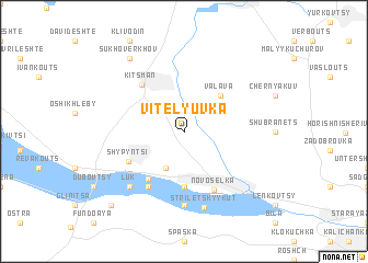
Vitelyuvka (Ukraine)Vitelyuvka is a town in Ukraine. An overview map of the region around Vitelyuvka is displayed below.
regional and 3d topo map of Vitelyuvka, Ukraine ::
Vitelyuvka airports ::
The nearest airport is SCV - Suceava Stefan Cel Mare, located 89.3 km south east of Vitelyuvka.
Other airports nearby include IAS - Iasi (192.5 km south east), LWO - Lvov Lviv Intl (206.9 km north west), BCM - Bacau (225.0 km south), TGM - Tirgu Mures Vidrasau (239.0 km south west), Nearby towns ::
Stara-Lyashkuvka (1.9km north) //
Nova-Lyashkuvka (2.2km north west) //
Luzhany (3.9km south) //
Valava (4.4km north east) //
Alʼtmamayeshti (5.6km south) //
Staroselʼye (5.4km south west) //
Kitsmanʼ (5.5km north west) //
Shypyntsi (4.8km south west) //
Novosëlka (6.2km south) //
Burdey (6.1km south west) //
Revna (7.4km south) //
Luk (6.7km south west) //
Striletsʼkyy Kut (7.7km south) //
Sukhoverkhov (8.3km north west) //
Korostovat (8.9km south west) //
[all distances 'as the bird flies' and approximate] 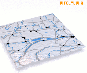 Places with similar names to Vitelyuvka, Ukraine ::
// Vital'yevka (RU)
Disclaimer :: Information on this page comes without warranty of any kind |
||
|
Where is Vitelyuvka? Elevation and coordinates ::
Latitude (lat): 48°24'0"N Longitude (lon): 25°48'0"E
Elevation (approx.): 181m (map arrows pan, magnifying glasses zoom) |
||
|
Visiting Vitelyuvka? Hotel/Accommodation ::
Book a hotel in Vitelyuvka Travel Guide ::
Buy a travel guide for Ukraine rental cars ::
car rental offers GPS waypoint ::
download a GPX waypoint (PoI) of Vitelyuvka for your GPS receiver
|
||