|
search place name
|
||
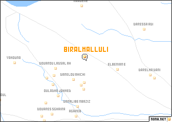
Biʼr al Mallūlī (Sfax, Tunisia)Biʼr al Mallūlī is a town in the Sfax region of Tunisia. An overview map of the region around Biʼr al Mallūlī is displayed below.
regional and 3d topo map of Biʼr al Mallūlī, Tunisia ::
Biʼr al Mallūlī airports ::
The nearest airport is SFA - Sfax Thyna, located 19.5 km south east of Biʼr al Mallūlī.
Other airports nearby include MIR - Monastir Habib Bourguiba Intl (102.5 km north), DJE - Djerba Zarzis (110.1 km south), GAE - Gabes (115.5 km south), GAF - Gafsa (165.4 km west), Nearby towns ::
Dar Ben el Ouaar (4.7km south) //
Dar el Ouahichi (4.6km south west) //
Dar Ben Mbarek (5.4km south) //
Dar Ben Nehar (6.2km south) //
Douar Oulad Salah (5.7km west) //
El Beniane (5.9km east) //
Borj Ben Reguiga (6.6km south west) //
Oulad Nouasseur (7.9km south west) //
Jebarna (8.0km south west) //
Oulad Haj Ahmed (9.1km south west) //
[all distances 'as the bird flies' and approximate] 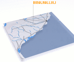 Places with similar names to Biʼr al Mallūlī, Tunisia :: Disclaimer :: Information on this page comes without warranty of any kind |
||
|
Where is Biʼr al Mallūlī? Elevation and coordinates ::
Latitude (lat): 34°51'0"N Longitude (lon): 10°33'0"E
Elevation (approx.): 120m (map arrows pan, magnifying glasses zoom) |
||
|
Visiting Biʼr al Mallūlī? Hotel/Accommodation ::
Book a hotel in Biʼr al Mallūlī Travel Guide ::
Buy a travel guide for Tunisia rental cars ::
car rental offers GPS waypoint ::
download a GPX waypoint (PoI) of Biʼr al Mallūlī for your GPS receiver
|
||