|
search place name
|
||
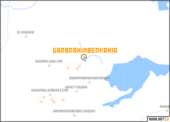
Dar Brahim Ben Kahia (Mahdia, Tunisia)Dar Brahim Ben Kahia is a town in the Mahdia region of Tunisia. An overview map of the region around Dar Brahim Ben Kahia is displayed below.
regional and 3d topo map of Dar Brahim Ben Kahia, Tunisia ::
Dar Brahim Ben Kahia airports ::
The nearest airport is MIR - Monastir Habib Bourguiba Intl, located 63.9 km north east of Dar Brahim Ben Kahia.
Other airports nearby include SFA - Sfax Thyna (85.1 km south east), TUN - Tunis Carthage (163.1 km north), GAF - Gafsa (166.3 km south west), GAE - Gabes (167.2 km south), Nearby towns ::
Douar Oulad Hassine Ben Abbas (1.5km south west) //
Douar Oulad Ahmed (2.1km south west) //
Douar Mohammed el Akerni (3.4km south west) //
Douar Mabrouk Ben Rehem (4.7km south) //
Dar et Touibia (6.8km south) //
Douar el Guelaïa (6.6km west) //
Douar en Nouilia (9.3km south west) //
Douar Salem Ben ez Zine (9.7km south west) //
Douar Khelifa Ben Slimane (10.3km south west) //
[all distances 'as the bird flies' and approximate]  Places with similar names to Dar Brahim Ben Kahia, Tunisia :: Disclaimer :: Information on this page comes without warranty of any kind |
||
|
Where is Dar Brahim Ben Kahia? Elevation and coordinates ::
Latitude (lat): 35°22'52"N Longitude (lon): 10°13'16"E
Elevation (approx.): 85m (map arrows pan, magnifying glasses zoom) |
||
|
Visiting Dar Brahim Ben Kahia? Hotel/Accommodation ::
Book a hotel in Dar Brahim Ben Kahia Travel Guide ::
Buy a travel guide for Tunisia rental cars ::
car rental offers GPS waypoint ::
download a GPX waypoint (PoI) of Dar Brahim Ben Kahia for your GPS receiver
|
||