|
search place name
|
||
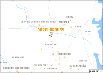
Dar el Aroussi (Sousse, Tunisia)Dar el Aroussi is a town in the Sousse region of Tunisia. An overview map of the region around Dar el Aroussi is displayed below.
regional and 3d topo map of Dar el Aroussi, Tunisia ::
Dar el Aroussi airports ::
The nearest airport is MIR - Monastir Habib Bourguiba Intl, located 57.4 km south east of Dar el Aroussi.
Other airports nearby include TUN - Tunis Carthage (82.2 km north), SFA - Sfax Thyna (158.9 km south), PNL - Pantelleria (169.4 km north east), GAF - Gafsa (230.3 km south west), Nearby towns ::
Ed Dzahibi (1.8km south) //
Oulad Mrabot (4.0km south) //
Oulad Mohammed el Alounia (5.5km south west) //
Dar Khaled (6.0km south) //
Takrūnah (5.6km north east) //
Zāwiyat Sīdī ‘Abd ar Raḩmān al Qārişī (5.6km north west) //
Oulad el Ghoulet (6.4km south) //
Cité Ouvrière (6.7km north east) //
Oulad el Meniou (8.0km south) //
Oulad Messaouda (8.7km south) //
Borj el Bey (8.9km south) //
Ez Zaouaoudi (8.5km south east) //
Bidane (8.3km north east) //
[all distances 'as the bird flies' and approximate]  Places with similar names to Dar el Aroussi, Tunisia ::
// Torre Lloris (ES)
// Douar Lerhzaoui (MA)
// Toury-Lurcy (FR)
// Treillières (FR)
// Dār al ‘Arāʼis (YE)
// Douar el Araïssïa (DZ)
// Dourlers (FR)
Disclaimer :: Information on this page comes without warranty of any kind |
||
|
Where is Dar el Aroussi? Elevation and coordinates ::
Latitude (lat): 36°6'44"N Longitude (lon): 10°17'30"E
Elevation (approx.): 51m (map arrows pan, magnifying glasses zoom) |
||
|
Visiting Dar el Aroussi? Hotel/Accommodation ::
Book a hotel in Dar el Aroussi Travel Guide ::
Buy a travel guide for Tunisia rental cars ::
car rental offers GPS waypoint ::
download a GPX waypoint (PoI) of Dar el Aroussi for your GPS receiver
|
||