|
search place name
|
||
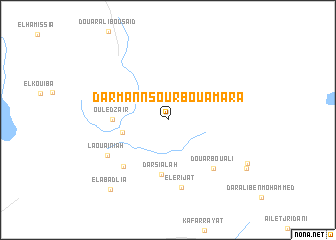
Dar Mannsour Bou Amara (Kairouan, Tunisia)Dar Mannsour Bou Amara is a town in the Kairouan region of Tunisia. An overview map of the region around Dar Mannsour Bou Amara is displayed below.
regional and 3d topo map of Dar Mannsour Bou Amara, Tunisia ::
Dar Mannsour Bou Amara airports ::
The nearest airport is SFA - Sfax Thyna, located 89.6 km south east of Dar Mannsour Bou Amara.
Other airports nearby include MIR - Monastir Habib Bourguiba Intl (97.6 km north east), GAF - Gafsa (132.7 km south west), GAE - Gabes (149.0 km south), TEE - Tebessa Cheikh Larbi Tebessi (164.8 km west), Nearby towns ::
Oulad Nasseur (4.3km west) //
Dar Sialah (6.1km south) //
Ouled Zaïr (5.1km west) //
Ouled Abd er Rahmane (6.6km south west) //
Douar Bou Ali (6.9km south east) //
El Erijat (7.7km south) //
Laouainiah (6.8km south west) //
El Abadlia (9.4km south west) //
Douar Amor Ben Ramah (8.8km south east) //
Douar Fellah (9.0km south east) //
[all distances 'as the bird flies' and approximate]  Places with similar names to Dar Mannsour Bou Amara, Tunisia :: Disclaimer :: Information on this page comes without warranty of any kind |
||
|
Where is Dar Mannsour Bou Amara? Elevation and coordinates ::
Latitude (lat): 35°12'38"N Longitude (lon): 9°54'47"E
Elevation (approx.): 176m (map arrows pan, magnifying glasses zoom) |
||
|
Visiting Dar Mannsour Bou Amara? Hotel/Accommodation ::
Book a hotel in Dar Mannsour Bou Amara Travel Guide ::
Buy a travel guide for Tunisia rental cars ::
car rental offers GPS waypoint ::
download a GPX waypoint (PoI) of Dar Mannsour Bou Amara for your GPS receiver
|
||