|
search place name
|
||
Diar el Hajjej (Tūnis al Janūbīyah, Tunisia)Diar el Hajjej is a town in the Tūnis al Janūbīyah region of Tunisia. An overview map of the region around Diar el Hajjej is displayed below.
regional and 3d topo map of Diar el Hajjej, Tunisia ::

Diar el Hajjej airports ::
The nearest airport is TUN - Tunis Carthage, located 61.9 km north west of Diar el Hajjej.
Other airports nearby include MIR - Monastir Habib Bourguiba Intl (96.9 km south), PNL - Pantelleria (101.1 km east), LMP - Lampedusa (201.8 km south east), TPS - Trapani Birgi (202.8 km north east), Nearby towns ::
Dar Ben Slimane (1.7km south east) //
Hennchir Bir Bou Zouita (2.8km north) //
Tobag (4.4km north) //
Krouibia (3.8km west) //
Korba (5.4km south) //
Kourchine (5.7km north) //
Tir el Mergueb (4.6km west) //
Beni Aïchoun (5.8km south) //
Dar Taleb Mohammed (5.8km north west) //
Dar Bou Agine (7.4km north west) //
Douar el Haj Salem Bou Kheïba (7.0km south west) //
Bou el Azhar (7.9km north west) //
Tafelloune (8.2km north east) //
Dar Hassen Zegoulli (7.2km north west) //
Tazarka (8.8km south) //
Dar Ben Zallout (9.2km north west) //
[all distances 'as the bird flies' and approximate] 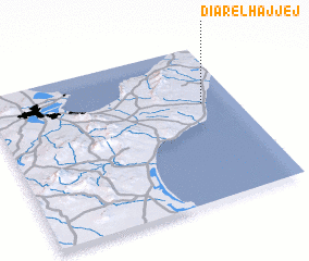 Places with similar names to Diar el Hajjej, Tunisia ::
// Douar el Hajaj (MA)
Disclaimer :: Information on this page comes without warranty of any kind |
||
|
Where is Diar el Hajjej? Elevation and coordinates ::
Latitude (lat): 36°37'37"N Longitude (lon): 10°51'41"E
Elevation (approx.): 17m (map arrows pan, magnifying glasses zoom) |
||
|
Visiting Diar el Hajjej? Hotel/Accommodation ::
Book a hotel in Diar el Hajjej Travel Guide ::
Buy a travel guide for Tunisia rental cars ::
car rental offers GPS waypoint ::
download a GPX waypoint (PoI) of Diar el Hajjej for your GPS receiver
|
||