|
search place name
|
||
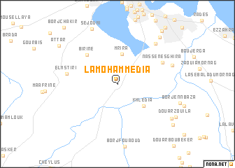
La Mohammedia (Tunis, Tunisia)La Mohammedia is a town in the Tunis region of Tunisia. An overview map of the region around La Mohammedia is displayed below.
regional and 3d topo map of La Mohammedia, Tunisia ::
La Mohammedia airports ::
The nearest airport is TUN - Tunis Carthage, located 20.4 km north of La Mohammedia.
Other airports nearby include MIR - Monastir Habib Bourguiba Intl (115.3 km south east), PNL - Pantelleria (162.7 km east), SFA - Sfax Thyna (222.7 km south), Nearby towns ::
Fouchana (2.8km north east) //
Mrira (4.8km north) //
Khledia (4.8km south east) //
Birine (6.0km north west) //
Nassene Sghira (6.7km north east) //
El Mstiri (6.7km west) //
Bir Kassa (8.1km north east) //
Nassene (7.6km north east) //
Sejoumi (9.4km north) //
La Bâtie (9.2km north east) //
Douar Kennjel (8.8km south east) //
Douar er Rahmane (9.6km south east) //
Ben Arous (10.2km north east) //
[all distances 'as the bird flies' and approximate] 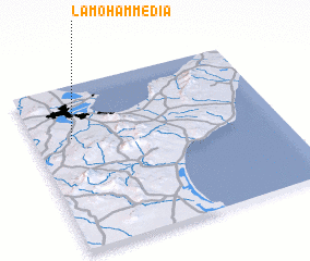 Places with similar names to La Mohammedia, Tunisia ::
// Lamhamid (MA)
Disclaimer :: Information on this page comes without warranty of any kind |
||
|
Where is La Mohammedia? Elevation and coordinates ::
Latitude (lat): 36°40'37"N Longitude (lon): 10°9'20"E
Elevation (approx.): 63m (map arrows pan, magnifying glasses zoom) |
||
|
Visiting La Mohammedia? Hotel/Accommodation ::
Book a hotel in La Mohammedia Travel Guide ::
Buy a travel guide for Tunisia rental cars ::
car rental offers GPS waypoint ::
download a GPX waypoint (PoI) of La Mohammedia for your GPS receiver
|
||