|
search place name
|
||
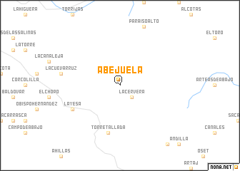
Abejuela (Aragón, Spain)Abejuela is a town in the Aragón region of Spain. An overview map of the region around Abejuela is displayed below.
regional and 3d topo map of Abejuela, Spain ::
Abejuela airports ::
The nearest airport is VLC - Valencia, located 58.6 km south east of Abejuela.
Other airports nearby include ALC - Alicante (183.6 km south), ZAZ - Zaragoza Ab (194.7 km north), Nearby towns ::
La Cervera (2.3km south east) //
Torre-Tallada (7.5km south) //
La Yesa (6.8km south west) //
[all distances 'as the bird flies' and approximate]  Places with similar names to Abejuela, Spain ::
// Abjūl (EG)
// Abejuela (ES)
// Abejuela (ES)
// Āb Gel (IR)
// Abū Jaylī (SD)
// Abū ‘Ujaylah (SY)
// Abū ‘Ajīlah (IQ)
// Abū ‘Ujaylah (EG)
Disclaimer :: Information on this page comes without warranty of any kind |
||
|
Where is Abejuela? Elevation and coordinates ::
Latitude (lat): 39°55'0"N Longitude (lon): 0°53'0"W
Elevation (approx.): 1272m (map arrows pan, magnifying glasses zoom) |
||
|
Visiting Abejuela? Hotel/Accommodation ::
Book a hotel in Abejuela Travel Guide ::
Buy a travel guide for Spain rental cars ::
car rental offers GPS waypoint ::
download a GPX waypoint (PoI) of Abejuela for your GPS receiver
|
||