|
search place name
|
||
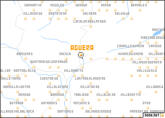
Agüera (Castilla y León, Spain)Agüera is a town in the Castilla y León region of Spain. An overview map of the region around Agüera is displayed below.
regional and 3d topo map of Agüera, Spain ::
Agüera airports ::
The nearest airport is SDR - Santander, located 47.1 km north west of Agüera.
Other airports nearby include BIO - Bilbao (49.2 km north east), VIT - Vitoria (63.9 km east), EAS - San Sebastian (137.8 km east), PNA - Pamplona (151.7 km east), Nearby towns ::
San Pelayo (1.4km east) //
Bercedo (1.9km south) //
Noceco (2.7km west) //
Quintanilla-Sopeña (3.7km south) //
Villasante (3.9km south) //
Leciñana de Mena (4.1km east) //
Montecillo (4.5km south west) //
Las Eras (5.7km south) //
Lastra de las Eras (5.7km south) //
Hedesa (5.5km south west) //
Loma de Montija (5.5km south west) //
Irús (5.4km east) //
Villatarás (7.5km south) //
La Calera del Prado (7.5km north) //
Colina (7.5km south) //
Quintana de los Prados (5.7km west) //
Barcenillas del Ribero (7.9km south) //
Villalázara (8.5km south west) //
Castrobarto (8.5km south east) //
Cuestaedo (7.8km south west) //
Quintanaedo (9.2km south west) //
[all distances 'as the bird flies' and approximate]  Places with similar names to Agüera, Spain ::
Disclaimer :: Information on this page comes without warranty of any kind |
||
|
Where is Agüera? Elevation and coordinates ::
Latitude (lat): 43°6'0"N Longitude (lon): 3°27'0"W
Elevation (approx.): 762m (map arrows pan, magnifying glasses zoom) |
||
|
Visiting Agüera? Hotel/Accommodation ::
Book a hotel in Agüera Travel Guide ::
Buy a travel guide for Spain rental cars ::
car rental offers GPS waypoint ::
download a GPX waypoint (PoI) of Agüera for your GPS receiver
|
||