|
search place name
|
||
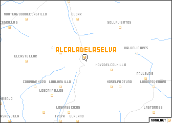
Alcalá de la Selva (Aragón, Spain)Alcalá de la Selva is a town in the Aragón region of Spain. An overview map of the region around Alcalá de la Selva is displayed below.
regional and 3d topo map of Alcalá de la Selva, Spain ::
Alcalá de la Selva airports ::
The nearest airport is VLC - Valencia, located 99.2 km south of Alcalá de la Selva.
Other airports nearby include ZAZ - Zaragoza Ab (147.2 km north), REU - Reus (179.9 km north east), Nearby towns ::
Casa Cosa (4.6km north west) //
Hoya del Colmillo (4.6km south east) //
Las Barracas (7.0km south east) //
La Olmedilla (7.0km south west) //
Mas El Fortuño (7.9km south east) //
Sollavientos (9.3km north east) //
Los Campillos (9.3km south west) //
[all distances 'as the bird flies' and approximate]  Places with similar names to Alcalá de la Selva, Spain :: Disclaimer :: Information on this page comes without warranty of any kind |
||
|
Where is Alcalá de la Selva? Elevation and coordinates ::
Latitude (lat): 40°22'0"N Longitude (lon): 0°42'0"W
Elevation (approx.): 1409m (map arrows pan, magnifying glasses zoom) |
||
|
Visiting Alcalá de la Selva? Hotel/Accommodation ::
Book a hotel in Alcalá de la Selva Travel Guide ::
Buy a travel guide for Spain rental cars ::
car rental offers GPS waypoint ::
download a GPX waypoint (PoI) of Alcalá de la Selva for your GPS receiver
|
||