|
search place name
|
||
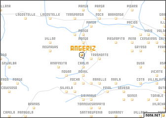
Angeriz (Cataluña, Spain)Angeriz is a town in the Cataluña region of Spain. An overview map of the region around Angeriz is displayed below.
regional and 3d topo map of Angeriz, Spain ::
Angeriz airports ::
The nearest airport is LCG - La Coruna A Coruna, located 49.6 km north west of Angeriz.
Other airports nearby include SCQ - Santiago (52.6 km south west), VGO - Vigo (116.3 km south west), OVD - Aviles Asturias (154.7 km east), BGC - Braganca (166.2 km south east), Nearby towns ::
Bra (1.4km east) //
Miraz (1.9km north) //
Carlín (1.9km south) //
Seijón (2.3km north east) //
Parga (3.7km north) //
Trasmonte (2.7km east) //
Roimil (3.7km south) //
Nodar (4.6km south west) //
Parga (5.6km north) //
Madelos (5.6km south) //
Lea (5.7km south) //
Becín (5.7km north) //
Anafreita (4.5km south west) //
Rocha (5.7km south) //
Ramelle (6.2km south east) //
Lamas (6.2km south east) //
Parga (7.5km north) //
Carballo (7.5km south) //
Negradas (5.7km west) //
Piedrafita (6.6km north east) //
Villar (6.6km north west) //
Mariz (6.6km north west) //
Silvela (7.9km south) //
Narla (7.8km south east) //
Friol (8.5km south east) //
[all distances 'as the bird flies' and approximate] 
Disclaimer :: Information on this page comes without warranty of any kind |
||
|
Where is Angeriz? Elevation and coordinates ::
Latitude (lat): 43°6'0"N Longitude (lon): 7°50'0"W
Elevation (approx.): 457m (map arrows pan, magnifying glasses zoom) |
||
|
Visiting Angeriz? Hotel/Accommodation ::
Book a hotel in Angeriz Travel Guide ::
Buy a travel guide for Spain rental cars ::
car rental offers GPS waypoint ::
download a GPX waypoint (PoI) of Angeriz for your GPS receiver
|
||