|
search place name
|
||
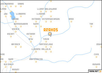
Arahós (Cataluña, Spain)Arahós is a town in the Cataluña region of Spain. An overview map of the region around Arahós is displayed below.
regional and 3d topo map of Arahós, Spain ::
Arahós airports ::
The nearest airport is LEU - Seo De Urgel, located 24.6 km south east of Arahós.
Other airports nearby include LRH - La Rochelle Lherm (101.7 km north), CCF - Carcassonne Salvaza (113.9 km north east), TLS - Toulouse Blagnac (122.0 km north), LDE - Tarbes Lourdes (126.4 km north west), Nearby towns ::
Tirvia (2.3km south west) //
Glorieta de Montescladó (3.7km south) //
Burch (3.7km south) //
Montescladó (4.0km south) //
Ribera de Cardós (4.6km north west) //
Esterri de Cardós (5.6km north) //
Farrera (5.6km south) //
Arrós (5.7km north) //
Mallolís (5.7km south) //
Surri (5.5km north west) //
Bonestarre (5.5km north west) //
Ginestarre (7.4km north) //
Estarón (5.5km west) //
Aydí (5.8km west) //
Anás (6.9km north west) //
Estahón (6.9km north west) //
Llavorsí (6.9km south west) //
Lladrós (7.9km north) //
Areo (7.8km north east) //
[all distances 'as the bird flies' and approximate] 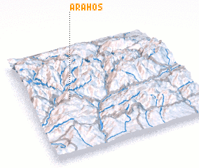
Disclaimer :: Information on this page comes without warranty of any kind |
||
|
Where is Arahós? Elevation and coordinates ::
Latitude (lat): 42°32'0"N Longitude (lon): 1°16'0"E
Elevation (approx.): 996m (map arrows pan, magnifying glasses zoom) |
||
|
Visiting Arahós? Hotel/Accommodation ::
Book a hotel in Arahós Travel Guide ::
Buy a travel guide for Spain rental cars ::
car rental offers GPS waypoint ::
download a GPX waypoint (PoI) of Arahós for your GPS receiver
|
||