|
search place name
|
||
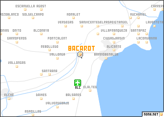
Bacarot (Comunidad Valenciana, Spain)Bacarot is a town in the Comunidad Valenciana region of Spain. An overview map of the region around Bacarot is displayed below.
regional and 3d topo map of Bacarot, Spain ::
Bacarot airports ::
The nearest airport is ALC - Alicante, located 5.7 km south of Bacarot.
Other airports nearby include MJV - Murcia San Javier (66.1 km south), VLC - Valencia (128.5 km north), IBZ - Ibiza (177.9 km east), LEI - Almeria (230.6 km south west), Nearby towns ::
Vallonga (4.4km west) //
Barrio Benalúa (4.4km east) //
Los Montoyos (6.3km north east) //
Font-Calent (5.7km north west) //
Calandari (7.4km north) //
El Alted (7.6km south) //
Rebolledo (6.1km west) //
Alicante (6.1km east) //
Cañada (8.0km north) //
San Vicente del Raspeig (8.0km north) //
Verdegás (8.0km north) //
Santa Ana (6.9km south west) //
Ciudad Jardín (6.9km north east) //
Villafranqueza (8.0km north east) //
[all distances 'as the bird flies' and approximate] 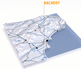 Places with similar names to Bacarot, Spain ::
Disclaimer :: Information on this page comes without warranty of any kind |
||
|
Where is Bacarot? Elevation and coordinates ::
Latitude (lat): 38°20'0"N Longitude (lon): 0°33'0"W
Elevation (approx.): 53m (map arrows pan, magnifying glasses zoom) |
||
|
Visiting Bacarot? Hotel/Accommodation ::
Book a hotel in Bacarot Travel Guide ::
Buy a travel guide for Spain rental cars ::
car rental offers GPS waypoint ::
download a GPX waypoint (PoI) of Bacarot for your GPS receiver
|
||