|
search place name
|
||
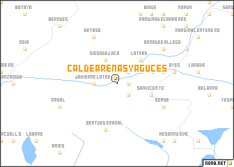
Caldearenas y Aguces (Aragón, Spain)Caldearenas y Aguces is a town in the Aragón region of Spain. An overview map of the region around Caldearenas y Aguces is displayed below.
regional and 3d topo map of Caldearenas y Aguces, Spain ::
Caldearenas y Aguces airports ::
The nearest airport is ZAZ - Zaragoza Ab, located 93.0 km south west of Caldearenas y Aguces.
Other airports nearby include LDE - Tarbes Lourdes (95.5 km north east), PNA - Pamplona (102.7 km north west), PUF - Pau Pyrenees (109.1 km north), BIQ - Biarritz-bayonne Anglet (145.1 km north west), Nearby towns ::
Estallo (1.4km east) //
Aquilué (2.3km south east) //
Latre (2.3km north east) //
Javierrelatre (2.7km west) //
Sieso de Jaca (4.0km north) //
Latrás (4.6km north east) //
San Vicente (4.5km south east) //
Bentué de Rasal (7.5km south) //
Lasieso (5.8km east) //
Serué (6.6km south east) //
Artaso (7.9km north) //
Orna de Gállego (7.8km north east) //
[all distances 'as the bird flies' and approximate] 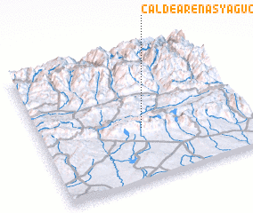 Places with similar names to Caldearenas y Aguces, Spain :: Disclaimer :: Information on this page comes without warranty of any kind |
||
|
Where is Caldearenas y Aguces? Elevation and coordinates ::
Latitude (lat): 42°24'0"N Longitude (lon): 0°30'0"W
Elevation (approx.): 641m (map arrows pan, magnifying glasses zoom) |
||
|
Visiting Caldearenas y Aguces? Hotel/Accommodation ::
Book a hotel in Caldearenas y Aguces Travel Guide ::
Buy a travel guide for Spain rental cars ::
car rental offers GPS waypoint ::
download a GPX waypoint (PoI) of Caldearenas y Aguces for your GPS receiver
|
||