|
search place name
|
||
Casas del Puerto de Villatoro (Castilla y León, Spain)Casas del Puerto de Villatoro is a town in the Castilla y León region of Spain. An overview map of the region around Casas del Puerto de Villatoro is displayed below.
regional and 3d topo map of Casas del Puerto de Villatoro, Spain ::

Casas del Puerto de Villatoro airports ::
The nearest airport is SLM - Salamanca, located 53.0 km north west of Casas del Puerto de Villatoro.
Other airports nearby include VLL - Valladolid (133.5 km north), MAD - Madrid Barajas (138.5 km east), TOJ - Madrid Torrejon (148.7 km east), BGC - Braganca (194.0 km north west), Nearby towns ::
Pajarejos (1.9km north) //
Villafranca de la Sierra (4.0km south) //
Cabezas de Bonilla (4.7km north west) //
Navacepedilla de Corneja (5.7km south) //
Villanueva del Campillo (6.2km north east) //
Garganta de los Hornos (6.2km south east) //
Tórtoles (5.6km north west) //
Bonilla de la Sierra (5.6km west) //
El Barrio (7.9km south west) //
Navaescurial (9.3km south west) //
[all distances 'as the bird flies' and approximate] 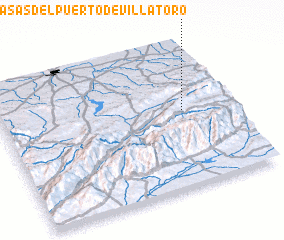 Places with similar names to Casas del Puerto de Villatoro, Spain :: Disclaimer :: Information on this page comes without warranty of any kind |
||
|
Where is Casas del Puerto de Villatoro? Elevation and coordinates ::
Latitude (lat): 40°32'0"N Longitude (lon): 5°12'0"W
Elevation (approx.): 1171m (map arrows pan, magnifying glasses zoom) |
||
|
Visiting Casas del Puerto de Villatoro? Hotel/Accommodation ::
Book a hotel in Casas del Puerto de Villatoro Travel Guide ::
Buy a travel guide for Spain rental cars ::
car rental offers GPS waypoint ::
download a GPX waypoint (PoI) of Casas del Puerto de Villatoro for your GPS receiver
|
||