|
search place name
|
||
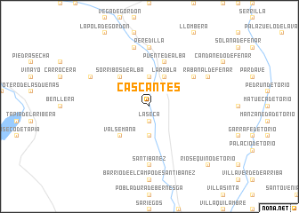
Cascantes (Castilla y León, Spain)Cascantes is a town in the Castilla y León region of Spain. An overview map of the region around Cascantes is displayed below.
regional and 3d topo map of Cascantes, Spain ::
Cascantes airports ::
The nearest airport is OVD - Aviles Asturias, located 94.4 km north of Cascantes.
Other airports nearby include BGC - Braganca (134.3 km south west), VLL - Valladolid (134.3 km south east), SDR - Santander (164.8 km north east), SLM - Salamanca (201.8 km south), Nearby towns ::
La Seca (1.9km south) //
Barrio Debesa (3.7km north) //
Llanos de Alba (3.7km north) //
Cabanillas (3.7km south) //
La Robla (3.9km north) //
Sorribos de Alba (4.6km north west) //
Valsemana (4.6km south west) //
Puente de Alba (5.7km north) //
Brugos de Fenar (5.5km north east) //
Peredilla (7.4km north) //
Santibáñez (7.4km south) //
Cuadros (7.4km south) //
Noceda (7.5km north) //
Rabanal de Fenar (6.6km north east) //
Olleros de Alba (6.6km north west) //
Ríosequino de Torío (9.2km south east) //
[all distances 'as the bird flies' and approximate] 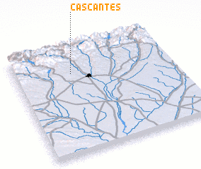
Disclaimer :: Information on this page comes without warranty of any kind |
||
|
Where is Cascantes? Elevation and coordinates ::
Latitude (lat): 42°46'0"N Longitude (lon): 5°38'0"W
Elevation (approx.): 975m (map arrows pan, magnifying glasses zoom) |
||
|
Visiting Cascantes? Hotel/Accommodation ::
Book a hotel in Cascantes Travel Guide ::
Buy a travel guide for Spain rental cars ::
car rental offers GPS waypoint ::
download a GPX waypoint (PoI) of Cascantes for your GPS receiver
|
||