|
search place name
|
||
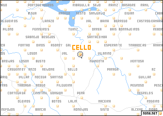
Cello (Galicia, Spain)Cello is a town in the Galicia region of Spain. An overview map of the region around Cello is displayed below.
regional and 3d topo map of Cello, Spain ::
Cello airports ::
The nearest airport is SCQ - Santiago, located 30.5 km north west of Cello.
Other airports nearby include LCG - La Coruna A Coruna (65.4 km north), VGO - Vigo (72.0 km south west), BGC - Braganca (151.7 km south east), VRL - Vila Real (166.9 km south), Nearby towns ::
Rodís (1.4km east) //
Cangas (1.4km east) //
Cercio (1.4km west) //
Galegos (2.3km north west) //
Palmou (2.3km south west) //
Camposancos (2.7km west) //
Val (2.7km west) //
Muimenta (3.3km south east) //
Carmoega (3.9km north) //
Sello (3.9km south) //
Santa Comba (4.6km north east) //
Bermés (4.6km south west) //
Cadrón (4.1km east) //
Vilariño (4.1km east) //
Fuentecabalos (5.7km south) //
Tuiriz (5.7km north) //
Brántega (5.7km north) //
Asorey (4.5km north west) //
Orrea (6.2km north east) //
Merlín (5.5km north east) //
Val (7.5km north) //
Esperante (5.7km east) //
Santiso (6.9km south west) //
Filgueira (7.9km south) //
Parada (6.6km south east) //
Alperiz (6.6km south east) //
Besejos (6.6km north west) //
Meijome (6.6km south west) //
Bais (7.8km north east) //
[all distances 'as the bird flies' and approximate]  Places with similar names to Cello, Spain ::
Disclaimer :: Information on this page comes without warranty of any kind |
||
|
Where is Cello? Elevation and coordinates ::
Latitude (lat): 42°45'0"N Longitude (lon): 8°6'0"W
Elevation (approx.): 451m (map arrows pan, magnifying glasses zoom) |
||
|
Visiting Cello? Hotel/Accommodation ::
Book a hotel in Cello Travel Guide ::
Buy a travel guide for Spain rental cars ::
car rental offers GPS waypoint ::
download a GPX waypoint (PoI) of Cello for your GPS receiver
|
||