|
search place name
|
||
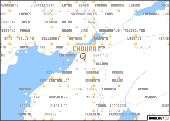
Choura (Galicia, Spain)Choura is a town in the Galicia region of Spain. An overview map of the region around Choura is displayed below.
regional and 3d topo map of Choura, Spain ::
Choura airports ::
The nearest airport is SCQ - Santiago, located 43.5 km east of Choura.
Other airports nearby include VGO - Vigo (64.0 km south), LCG - La Coruna A Coruna (74.0 km north east), OPO - Porto (169.8 km south), VRL - Vila Real (193.1 km south east), Nearby towns ::
Argalo (0.0km north) //
Baya (0.0km north) //
Miñortos (1.4km west) //
Taramancos (1.9km north) //
Obre (1.9km north) //
Carreira (1.9km north) //
Merelle (1.4km east) //
Vilaboa (1.9km south) //
Camboño (1.9km south) //
Argellas (1.9km south) //
Boa (2.3km north west) //
Portosin (2.3km south west) //
Abeijón (2.3km south east) //
Tavilo (3.7km north) //
Serantes (3.7km north) //
Linteiros (2.7km west) //
Berrimes (2.7km east) //
Marracín de Abajo (2.7km east) //
Marracín de Arriba (2.7km east) //
Esteiro (3.9km north) //
Barquiña (3.9km north) //
Barro (3.9km north) //
Beneso (3.3km south west) //
Silva (3.3km south west) //
Goyanes (3.3km south west) //
Noya (3.3km north east) //
Cruido (3.3km north east) //
Tállara (3.3km south east) //
Chave (3.3km south east) //
[all distances 'as the bird flies' and approximate]  Places with similar names to Choura, Spain ::
Disclaimer :: Information on this page comes without warranty of any kind |
||
|
Where is Choura? Elevation and coordinates ::
Latitude (lat): 42°46'0"N Longitude (lon): 8°55'0"W
Elevation (approx.): 209m (map arrows pan, magnifying glasses zoom) |
||
|
Visiting Choura? Hotel/Accommodation ::
Book a hotel in Choura Travel Guide ::
Buy a travel guide for Spain rental cars ::
car rental offers GPS waypoint ::
download a GPX waypoint (PoI) of Choura for your GPS receiver
|
||