|
search place name
|
||
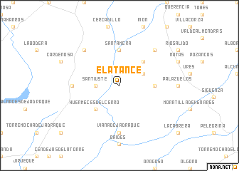
El Atance (Castilla-La Mancha, Spain)El Atance is a town in the Castilla-La Mancha region of Spain. An overview map of the region around El Atance is displayed below.
regional and 3d topo map of El Atance, Spain ::
El Atance airports ::
The nearest airport is TOJ - Madrid Torrejon, located 86.8 km south west of El Atance.
Other airports nearby include MAD - Madrid Barajas (94.1 km south west), ZAZ - Zaragoza Ab (158.2 km north east), VIT - Vitoria (199.9 km north), PNA - Pamplona (209.1 km north east), Nearby towns ::
Santiuste (2.8km west) //
Cirueches (3.4km north east) //
Huérmeces del Cerro (4.6km south west) //
La Olmeda de Jadraque (4.6km north east) //
Santamera (5.6km north) //
Carabias (4.2km east) //
Viana de Jadraque (7.4km south) //
Rebollosa de Jadraque (5.6km west) //
Bujalcayado (7.0km north east) //
Ríofrío del Llano (7.0km north west) //
[all distances 'as the bird flies' and approximate] 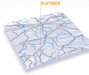 Places with similar names to El Atance, Spain ::
// El Túnez (MX)
Disclaimer :: Information on this page comes without warranty of any kind |
||
|
Where is El Atance? Elevation and coordinates ::
Latitude (lat): 41°5'0"N Longitude (lon): 2°46'0"W
Elevation (approx.): 919m (map arrows pan, magnifying glasses zoom) |
||
|
Visiting El Atance? Hotel/Accommodation ::
Book a hotel in El Atance Travel Guide ::
Buy a travel guide for Spain rental cars ::
car rental offers GPS waypoint ::
download a GPX waypoint (PoI) of El Atance for your GPS receiver
|
||