|
search place name
|
||
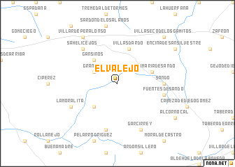
El Valejo (Castilla y León, Spain)El Valejo is a town in the Castilla y León region of Spain. An overview map of the region around El Valejo is displayed below.
regional and 3d topo map of El Valejo, Spain ::
El Valejo airports ::
The nearest airport is SLM - Salamanca, located 56.0 km east of El Valejo.
Other airports nearby include BGC - Braganca (108.8 km north west), VRL - Vila Real (134.9 km west), VLL - Valladolid (137.3 km north east), Nearby towns ::
Grandes (3.4km north west) //
Gansinos (4.6km north west) //
Castillejo de Eváns (4.6km south west) //
Santa María de Sando (4.6km north east) //
Villasdardo (5.7km north) //
Sando (5.6km east) //
Casasola de la Encomienda (7.5km south) //
Fuentes de Sando (5.9km east) //
Sahelicejos (7.0km north west) //
La Moralita (6.7km south west) //
Garcirrey (7.9km south) //
Villar de Peralonso (8.5km north west) //
Villaseco de los Gamitos (9.3km north east) //
[all distances 'as the bird flies' and approximate] 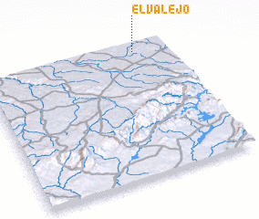 Places with similar names to El Valejo, Spain ::
// Eola Village (US)
// El Vallejo (ES)
Disclaimer :: Information on this page comes without warranty of any kind |
||
|
Where is El Valejo? Elevation and coordinates ::
Latitude (lat): 40°58'0"N Longitude (lon): 6°10'0"W
Elevation (approx.): 804m (map arrows pan, magnifying glasses zoom) |
||
|
Visiting El Valejo? Hotel/Accommodation ::
Book a hotel in El Valejo Travel Guide ::
Buy a travel guide for Spain rental cars ::
car rental offers GPS waypoint ::
download a GPX waypoint (PoI) of El Valejo for your GPS receiver
|
||