|
search place name
|
||
Ferrol (Galicia, Spain)Ferrol is a town in the Galicia region of Spain. An overview map of the region around Ferrol is displayed below.
regional and 3d topo map of Ferrol, Spain ::

Ferrol airports ::
The nearest airport is LCG - La Coruna A Coruna, located 23.3 km south west of Ferrol.
Other airports nearby include SCQ - Santiago (66.9 km south), VGO - Vigo (142.7 km south), BGC - Braganca (219.7 km south east), Nearby towns ::
Villar (0.0km north) //
La Malata (0.9km north) //
Serantes (1.9km north) //
Mehá (2.3km south west) //
Mugardos (2.3km south west) //
El Seijo (3.0km south east) //
Caranza (2.7km east) //
Brion (2.7km west) //
La Graña (2.7km west) //
La Cabana (2.7km west) //
Franza (3.9km south) //
Filgueira (3.3km north east) //
Trasancos (3.3km north east) //
Cervás (4.6km south west) //
Leija (4.6km north east) //
Esmelle (4.6km north west) //
Ares (5.6km south) //
Montón (4.0km east) //
Doniños (4.0km west) //
Mandiá (5.6km north) //
Perlio (4.4km south east) //
Maniños (4.4km south east) //
Trasancos (5.7km north) //
San Martin de Jubia (4.4km north east) //
Marmancón (5.7km north) //
Barallobre (5.5km south east) //
Caamouco (6.2km south east) //
Piñeiro (6.2km south east) //
Redes (6.9km south) //
[all distances 'as the bird flies' and approximate] 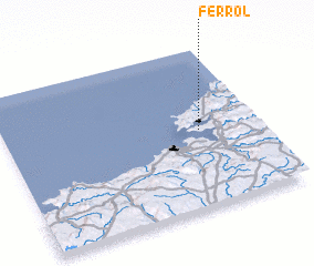 Places with similar names to Ferrol, Spain ::
Disclaimer :: Information on this page comes without warranty of any kind |
||
|
Where is Ferrol? Elevation and coordinates ::
Latitude (lat): 43°29'0"N Longitude (lon): 8°14'0"W
Elevation (approx.): 20m (map arrows pan, magnifying glasses zoom) |
||
|
Visiting Ferrol? Hotel/Accommodation ::
Book a hotel in Ferrol Travel Guide ::
Buy a travel guide for Spain rental cars ::
car rental offers GPS waypoint ::
download a GPX waypoint (PoI) of Ferrol for your GPS receiver
|
||