|
search place name
|
||
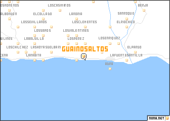
Guainos Altos (Andalucía, Spain)Guainos Altos is a town in the Andalucía region of Spain. An overview map of the region around Guainos Altos is displayed below.
regional and 3d topo map of Guainos Altos, Spain ::
Guainos Altos airports ::
The nearest airport is LEI - Almeria, located 63.0 km east of Guainos Altos.
Other airports nearby include GRX - Granada Armilla (66.2 km north west), GRX - Granada (79.8 km north west), AGP - Malaga (128.3 km west), MLN - Melilla (163.4 km south), Nearby towns ::
La Alcazaba (1.5km west) //
La Parra (3.7km north) //
Los Pérez (4.0km north) //
La Romera (3.5km north east) //
Buenavista (4.7km north west) //
Los Valentines (5.8km north) //
Adra (4.8km south east) //
Los Dagas (6.3km north west) //
Los Curros (5.8km north east) //
Los Enríquez (5.8km north east) //
Los Clementes (7.4km north) //
Las Hoyas del Barranco (6.2km west) //
La Alquería (7.0km north east) //
El Río Grande (8.6km north east) //
Cuesta Vieja (9.5km north west) //
[all distances 'as the bird flies' and approximate] 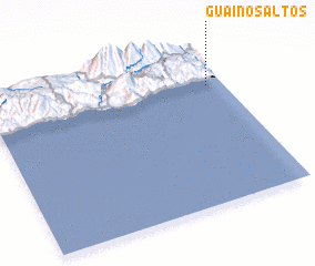 Places with similar names to Guainos Altos, Spain ::
// Cancelides (PH)
Disclaimer :: Information on this page comes without warranty of any kind |
||
|
Where is Guainos Altos? Elevation and coordinates ::
Latitude (lat): 36°45'0"N Longitude (lon): 3°4'0"W
Elevation (approx.): 78m (map arrows pan, magnifying glasses zoom) |
||
|
Visiting Guainos Altos? Hotel/Accommodation ::
Book a hotel in Guainos Altos Travel Guide ::
Buy a travel guide for Spain rental cars ::
car rental offers GPS waypoint ::
download a GPX waypoint (PoI) of Guainos Altos for your GPS receiver
|
||