|
search place name
|
||
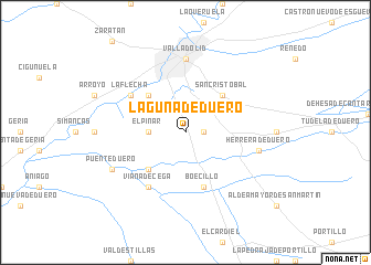
Laguna de Duero (Castilla y León, Spain)Laguna de Duero is a town in the Castilla y León region of Spain. An overview map of the region around Laguna de Duero is displayed below.
regional and 3d topo map of Laguna de Duero, Spain ::
Laguna de Duero airports ::
The nearest airport is VLL - Valladolid, located 17.7 km north west of Laguna de Duero.
Other airports nearby include SLM - Salamanca (96.1 km south west), MAD - Madrid Barajas (154.9 km south east), TOJ - Madrid Torrejon (161.2 km south east), BGC - Braganca (168.4 km west), Nearby towns ::
Villar (1.4km east) //
El Pinar (2.8km west) //
La Vega de Porras (4.6km south west) //
Granja Agrícola (4.6km north west) //
Cistérniga (4.6km north east) //
San Cristóbal (4.6km north east) //
Boecillo (5.7km south) //
Viana de Cega (6.2km south west) //
La Flecha (5.6km north west) //
Valladolid (7.4km north) //
Herrera de Duero (5.8km east) //
Puente Duero (6.7km south west) //
[all distances 'as the bird flies' and approximate]  Places with similar names to Laguna de Duero, Spain ::
// Lo Contador (CL)
// La Contadera (MX)
Disclaimer :: Information on this page comes without warranty of any kind |
||
|
Where is Laguna de Duero? Elevation and coordinates ::
Latitude (lat): 41°35'0"N Longitude (lon): 4°43'0"W
Elevation (approx.): 703m (map arrows pan, magnifying glasses zoom) |
||
|
Visiting Laguna de Duero? Hotel/Accommodation ::
Book a hotel in Laguna de Duero Travel Guide ::
Buy a travel guide for Spain rental cars ::
car rental offers GPS waypoint ::
download a GPX waypoint (PoI) of Laguna de Duero for your GPS receiver
|
||