|
search place name
|
||
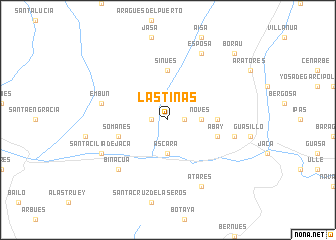
Las Tinas (Aragón, Spain)Las Tinas is a town in the Aragón region of Spain. An overview map of the region around Las Tinas is displayed below.
regional and 3d topo map of Las Tinas, Spain ::
Las Tinas airports ::
The nearest airport is LDE - Tarbes Lourdes, located 83.0 km north east of Las Tinas.
Other airports nearby include PNA - Pamplona (83.8 km west), PUF - Pau Pyrenees (88.7 km north), ZAZ - Zaragoza Ab (108.7 km south), BIQ - Biarritz-bayonne Anglet (119.9 km north west), Nearby towns ::
Fraginal (1.4km west) //
Araguás del Solano (1.4km east) //
Novés (2.7km east) //
Ascara (3.7km south) //
Sinués (5.6km north) //
Caniás (4.1km east) //
Somanés (4.5km south west) //
Abay (4.5km south east) //
Banaguás (5.8km east) //
Embún (5.8km west) //
Binacua (6.9km south west) //
Esposa (7.9km north) //
Atarés (7.9km south) //
Santa Cilia de Jaca (6.6km south west) //
Borau (9.2km north east) //
[all distances 'as the bird flies' and approximate]  Places with similar names to Las Tinas, Spain ::
// Las Dueñas (PA)
// Lestans (IT)
// Las Tunas (CU)
// Las Tunas (CU)
// Las Dueñas (ES)
// Lastanosa (ES)
// Los Teones (ES)
// Los Tanos (US)
// Las Tunas (CL)
// Los Dones (CL)
Disclaimer :: Information on this page comes without warranty of any kind |
||
|
Where is Las Tinas? Elevation and coordinates ::
Latitude (lat): 42°36'0"N Longitude (lon): 0°39'0"W
Elevation (approx.): 806m (map arrows pan, magnifying glasses zoom) |
||
|
Visiting Las Tinas? Hotel/Accommodation ::
Book a hotel in Las Tinas Travel Guide ::
Buy a travel guide for Spain rental cars ::
car rental offers GPS waypoint ::
download a GPX waypoint (PoI) of Las Tinas for your GPS receiver
|
||