|
search place name
|
||
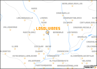
Los Olivares (Andalucía, Spain)Los Olivares is a town in the Andalucía region of Spain. An overview map of the region around Los Olivares is displayed below.
regional and 3d topo map of Los Olivares, Spain ::
Los Olivares airports ::
The nearest airport is GRX - Granada, located 16.1 km south of Los Olivares.
Other airports nearby include GRX - Granada Armilla (25.1 km south east), AGP - Malaga (97.9 km south west), ODB - Cordoba (111.0 km north west), LEI - Almeria (135.5 km south east), Nearby towns ::
Moclín (1.5km west) //
Tiena la Baja (2.4km south west) //
Berbe-Bajo (2.9km east) //
Tózar (4.0km north) //
Búcor (5.6km south) //
Limones (5.8km north) //
Buenavista (4.8km north west) //
Cozcojar (6.3km south west) //
Puerto-López (5.9km west) //
Casa Nueva (7.6km south) //
Zujaira (8.0km south) //
Colomera (7.0km north east) //
Caparacena (8.6km south east) //
Casa Caurilla (8.6km north east) //
[all distances 'as the bird flies' and approximate] 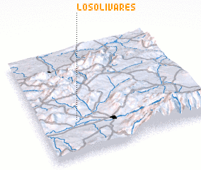 Places with similar names to Los Olivares, Spain ::
// Las Oliveras (ES)
// Los Alvarez (US)
// Los Álvarez (MX)
// Los Alfaros (HN)
// Los Olivares (AR)
// Les Olliviers (FR)
Disclaimer :: Information on this page comes without warranty of any kind |
||
|
Where is Los Olivares? Elevation and coordinates ::
Latitude (lat): 37°20'0"N Longitude (lon): 3°46'0"W
Elevation (approx.): 646m (map arrows pan, magnifying glasses zoom) |
||
|
Visiting Los Olivares? Hotel/Accommodation ::
Book a hotel in Los Olivares Travel Guide ::
Buy a travel guide for Spain rental cars ::
car rental offers GPS waypoint ::
download a GPX waypoint (PoI) of Los Olivares for your GPS receiver
|
||