|
search place name
|
||
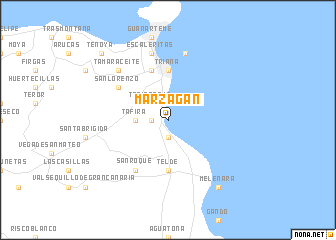
Marzagán (Canarias, Spain)Marzagán is a town in the Canarias region of Spain. An overview map of the region around Marzagán is displayed below.
regional and 3d topo map of Marzagán, Spain ::
Marzagán airports ::
The nearest airport is LPA - Gran Canaria, located 13.4 km south of Marzagán.
Other airports nearby include TFN - Tenerife Norte (102.6 km north west), TFS - Tenerife Sur (113.6 km west), FUE - Fuerteventura (158.8 km east), ACE - Lanzerote Lanzarote (203.2 km north east), Nearby towns ::
San Francisco de Paula (1.6km west) //
Jinámar (1.9km south) //
Tafira Baja (2.5km north west) //
Tafira (3.3km west) //
Triana (5.6km north) //
Las Palmas de Gran Canaria (5.6km north) //
Telde (5.6km south) //
Las Rehoyas (5.8km north) //
Dragonal (6.1km north west) //
San Lorenzo (6.1km north west) //
San Roque (6.5km south west) //
Ciudad Jardín (7.6km north) //
Escaleritas (7.6km north) //
Arenales (7.6km north) //
Tamaraceite (7.4km north west) //
Melenara (8.9km south east) //
Tenoya (9.9km north west) //
[all distances 'as the bird flies' and approximate]  Places with similar names to Marzagán, Spain ::
// Moroskino (RU)
// Morozkino (RU)
// Morozkino (RU)
// Marosakoana (MG)
// Marosakoana (MG)
// Marosakoana (MG)
// Muarasukon (ID)
// Marzagânia (BR)
// Marcigny (FR)
// Marcigny (FR)
Disclaimer :: Information on this page comes without warranty of any kind |
||
|
Where is Marzagán? Elevation and coordinates ::
Latitude (lat): 28°3'0"N Longitude (lon): 15°25'0"W
Elevation (approx.): 61m (map arrows pan, magnifying glasses zoom) |
||
|
Visiting Marzagán? Hotel/Accommodation ::
Book a hotel in Marzagán Travel Guide ::
Buy a travel guide for Spain rental cars ::
car rental offers GPS waypoint ::
download a GPX waypoint (PoI) of Marzagán for your GPS receiver
|
||