|
search place name
|
||
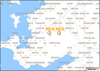
Meis (Galicia, Spain)Meis is a town in the Galicia region of Spain. An overview map of the region around Meis is displayed below.
regional and 3d topo map of Meis, Spain ::
Meis airports ::
The nearest airport is VGO - Vigo, located 31.5 km south of Meis.
Other airports nearby include SCQ - Santiago (51.9 km north east), LCG - La Coruna A Coruna (94.2 km north), OPO - Porto (139.2 km south), VRL - Vila Real (160.7 km south east), Nearby towns ::
Barrantes (0.0km north) //
Ribadumia (1.9km north) //
Besomaño (2.3km north east) //
Covas (2.3km south west) //
Meis (2.7km east) //
Vilariño (3.3km north west) //
Nogueira (3.3km north east) //
Padrenda (3.3km south west) //
Armentera (4.0km south) //
Leiro (4.0km north) //
Oubiña (4.0km north) //
Gil (4.0km south) //
Tremoedo (4.6km north west) //
Lois (4.6km north east) //
Soloveira (5.6km north) //
Cambados (4.1km west) //
Serantes (5.7km north) //
Nogueira (4.5km north east) //
Quintáns (4.5km south west) //
Cacabelos (4.5km north west) //
Paradela (6.2km north east) //
Meaño (6.2km south west) //
Simes (7.5km south) //
Bouza (5.8km west) //
Castrelo (5.8km west) //
Portela (5.8km east) //
Deiro (6.9km north west) //
Dena (6.9km south west) //
Lores (7.9km south) //
[all distances 'as the bird flies' and approximate]  Places with similar names to Meis, Spain ::
Disclaimer :: Information on this page comes without warranty of any kind |
||
|
Where is Meis? Elevation and coordinates ::
Latitude (lat): 42°30'0"N Longitude (lon): 8°45'0"W
Elevation (approx.): 98m (map arrows pan, magnifying glasses zoom) |
||
|
Visiting Meis? Hotel/Accommodation ::
Book a hotel in Meis Travel Guide ::
Buy a travel guide for Spain rental cars ::
car rental offers GPS waypoint ::
download a GPX waypoint (PoI) of Meis for your GPS receiver
|
||