|
search place name
|
||
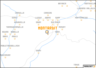
Montardit (Cataluña, Spain)Montardit is a town in the Cataluña region of Spain. An overview map of the region around Montardit is displayed below.
regional and 3d topo map of Montardit, Spain ::
Montardit airports ::
The nearest airport is LEU - Seo De Urgel, located 26.4 km east of Montardit.
Other airports nearby include LRH - La Rochelle Lherm (117.3 km north), LDE - Tarbes Lourdes (125.2 km north west), CCF - Carcassonne Salvaza (134.0 km north east), TLS - Toulouse Blagnac (138.2 km north), Nearby towns ::
Enviny (0.0km north) //
Sort (2.7km east) //
Olp (4.0km north) //
Sauri (4.6km north west) //
Rialp (4.6km north east) //
Sorré (5.6km north) //
Peruny (4.5km north east) //
Altrón (5.7km north) //
Bernúy (5.7km north) //
Llesúy (6.2km north west) //
Surp (6.2km north east) //
Caregné (7.4km north) //
Gerri (7.9km south) //
[all distances 'as the bird flies' and approximate]  Places with similar names to Montardit, Spain ::
Disclaimer :: Information on this page comes without warranty of any kind |
||
|
Where is Montardit? Elevation and coordinates ::
Latitude (lat): 42°24'0"N Longitude (lon): 1°6'0"E
Elevation (approx.): 1096m (map arrows pan, magnifying glasses zoom) |
||
|
Visiting Montardit? Hotel/Accommodation ::
Book a hotel in Montardit Travel Guide ::
Buy a travel guide for Spain rental cars ::
car rental offers GPS waypoint ::
download a GPX waypoint (PoI) of Montardit for your GPS receiver
|
||