|
search place name
|
||
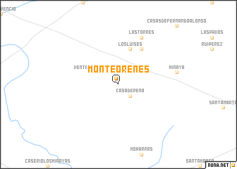
Monte Orenes (Castilla-La Mancha, Spain)Monte Orenes is a town in the Castilla-La Mancha region of Spain. An overview map of the region around Monte Orenes is displayed below.
regional and 3d topo map of Monte Orenes, Spain ::
Monte Orenes airports ::
The nearest airport is TOJ - Madrid Torrejon, located 163.3 km north west of Monte Orenes.
Other airports nearby include VLC - Valencia (167.1 km east), MAD - Madrid Barajas (168.9 km north west), ALC - Alicante (193.8 km south east), MJV - Murcia San Javier (215.8 km south east), Nearby towns ::
Casas de Roldán (2.3km north east) //
Casa de Peña (2.3km south east) //
Ventas de Alcolea (3.4km north west) //
Los Luises (5.7km north) //
Los Estesos (6.3km north east) //
Los Torres (7.9km north) //
Casas de los Pinos (7.9km north) //
[all distances 'as the bird flies' and approximate] 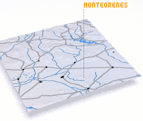 Places with similar names to Monte Orenes, Spain ::
// Monterensie (CD)
// Monteranos (MX)
// Monterenzio (IT)
// Montournais (FR)
// Montornés (ES)
// Mount Torrens (AU)
Disclaimer :: Information on this page comes without warranty of any kind |
||
|
Where is Monte Orenes? Elevation and coordinates ::
Latitude (lat): 39°16'0"N Longitude (lon): 2°24'0"W
Elevation (approx.): 715m (map arrows pan, magnifying glasses zoom) |
||
|
Visiting Monte Orenes? Hotel/Accommodation ::
Book a hotel in Monte Orenes Travel Guide ::
Buy a travel guide for Spain rental cars ::
car rental offers GPS waypoint ::
download a GPX waypoint (PoI) of Monte Orenes for your GPS receiver
|
||