|
search place name
|
||
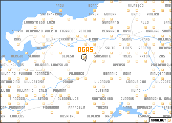
Ogas (Galicia, Spain)Ogas is a town in the Galicia region of Spain. An overview map of the region around Ogas is displayed below.
regional and 3d topo map of Ogas, Spain ::
Ogas airports ::
The nearest airport is SCQ - Santiago, located 56.5 km south east of Ogas.
Other airports nearby include LCG - La Coruna A Coruna (59.1 km north east), VGO - Vigo (102.5 km south), OPO - Porto (207.9 km south), VRL - Vila Real (230.6 km south east), Nearby towns ::
Cambeda (1.4km east) //
Rasamonde (1.4km east) //
Pasantes (1.9km north) //
Valiña (1.9km north) //
La Toja (1.9km north) //
Vimianzo (2.3km north east) //
Casais (2.3km north east) //
Calo (3.7km north) //
Devesa (2.7km west) //
Sansobre (2.7km east) //
Lavandeira (3.7km south) //
Piñeiros (3.7km south) //
Sanfins (3.7km south) //
Cerbán (3.7km south) //
Castrelo (3.7km south) //
Roalo (3.7km south) //
Irroa (3.9km north) //
Santa Cristina (3.3km south west) //
Vilaseco (3.9km south) //
Carantoña (4.6km north west) //
Boallo (4.6km south west) //
Bouza (4.6km south west) //
Pasarela (5.6km north) //
Penedo (5.6km north) //
Magro (5.7km north) //
Montecelos (4.5km north west) //
Salto (4.5km north east) //
Castro (4.5km north east) //
Padreiro de Abajo (5.7km south) //
[all distances 'as the bird flies' and approximate]  Places with similar names to Ogas, Spain ::
Disclaimer :: Information on this page comes without warranty of any kind |
||
|
Where is Ogas? Elevation and coordinates ::
Latitude (lat): 43°6'0"N Longitude (lon): 9°3'0"W
Elevation (approx.): 173m (map arrows pan, magnifying glasses zoom) |
||
|
Visiting Ogas? Hotel/Accommodation ::
Book a hotel in Ogas Travel Guide ::
Buy a travel guide for Spain rental cars ::
car rental offers GPS waypoint ::
download a GPX waypoint (PoI) of Ogas for your GPS receiver
|
||