|
search place name
|
||
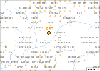
Rey (Cataluña, Spain)Rey is a town in the Cataluña region of Spain. An overview map of the region around Rey is displayed below.
regional and 3d topo map of Rey, Spain ::
Rey airports ::
The nearest airport is SCQ - Santiago, located 88.1 km west of Rey.
Other airports nearby include BGC - Braganca (101.1 km south east), VGO - Vigo (107.7 km west), LCG - La Coruna A Coruna (110.6 km north west), VRL - Vila Real (149.4 km south), Nearby towns ::
Veiga (1.4km east) //
Canedo (1.9km north) //
Freituje (1.9km north) //
Mosteiro (2.3km north west) //
Eijón (2.3km south west) //
Castrosante (2.3km south east) //
Layosa (3.7km north) //
Ferreirúa (2.7km east) //
Fornelas (3.9km south) //
Guntín (3.3km north west) //
Saá (3.3km south east) //
Ribas Pequeñas (4.1km west) //
Ferreiros (4.1km east) //
Cereija (5.6km south) //
Bóveda (5.5km north west) //
Tuimil (6.2km north west) //
Parte (5.5km south west) //
Lamaiglesia (5.5km south east) //
Óutara (6.2km north east) //
Castroncelos (6.2km south east) //
Villasoto (7.4km north) //
Ver (5.8km west) //
Chavaga (7.5km south) //
Eirejalba (7.5km north) //
Rubián (6.9km north west) //
Puebla del Brollón (6.9km south east) //
Valverde (6.6km south west) //
Incio (6.6km north east) //
Bascós (7.9km south) //
[all distances 'as the bird flies' and approximate]  Places with similar names to Rey, Spain ::
Disclaimer :: Information on this page comes without warranty of any kind |
||
|
Where is Rey? Elevation and coordinates ::
Latitude (lat): 42°36'0"N Longitude (lon): 7°25'0"W
Elevation (approx.): 418m (map arrows pan, magnifying glasses zoom) |
||
|
Visiting Rey? Hotel/Accommodation ::
Book a hotel in Rey Travel Guide ::
Buy a travel guide for Spain rental cars ::
car rental offers GPS waypoint ::
download a GPX waypoint (PoI) of Rey for your GPS receiver
|
||