|
search place name
|
||
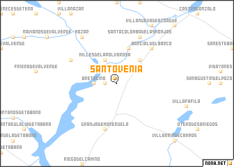
Santovenia (Castilla y León, Spain)Santovenia is a town in the Castilla y León region of Spain. An overview map of the region around Santovenia is displayed below.
regional and 3d topo map of Santovenia, Spain ::
Santovenia airports ::
The nearest airport is VLL - Valladolid, located 74.5 km east of Santovenia.
Other airports nearby include BGC - Braganca (82.3 km west), SLM - Salamanca (105.0 km south), OVD - Aviles Asturias (188.5 km north), SDR - Santander (231.5 km north east), Nearby towns ::
Bretó (1.4km west) //
Bretocino (2.8km west) //
Olmillos de Valverde (3.3km north west) //
Milles de la Polvorosa (4.0km north) //
Villaveza del Agua (4.6km north east) //
Arcos de la Polvorosa (5.7km north) //
Granja de Moreruela (7.5km south) //
Barcial del Barco (6.9km north east) //
Burganes de Valverde (6.6km north west) //
Santa Colomba de las Monjas (7.9km north) //
Mózar (8.5km north west) //
[all distances 'as the bird flies' and approximate] 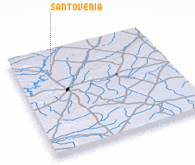 Places with similar names to Santovenia, Spain ::
// Sandvin (NO)
// Santovenia (CU)
// Santoveña (ES)
// Santovenia (ES)
// Santovenia (ES)
// Sindavni (IN)
// Sindvāni (IN)
// Zendevān (IR)
// Saint-Yvoine (FR)
// Saint-Yvon (BE)
Disclaimer :: Information on this page comes without warranty of any kind |
||
|
Where is Santovenia? Elevation and coordinates ::
Latitude (lat): 41°53'0"N Longitude (lon): 5°43'0"W
Elevation (approx.): 693m (map arrows pan, magnifying glasses zoom) |
||
|
Visiting Santovenia? Hotel/Accommodation ::
Book a hotel in Santovenia Travel Guide ::
Buy a travel guide for Spain rental cars ::
car rental offers GPS waypoint ::
download a GPX waypoint (PoI) of Santovenia for your GPS receiver
|
||