|
search place name
|
||
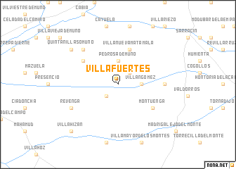
Villafuertes (Castilla y León, Spain)Villafuertes is a town in the Castilla y León region of Spain. An overview map of the region around Villafuertes is displayed below.
regional and 3d topo map of Villafuertes, Spain ::
Villafuertes airports ::
The nearest airport is VLL - Valladolid, located 102.1 km south west of Villafuertes.
Other airports nearby include VIT - Vitoria (117.7 km north east), SDR - Santander (138.2 km north), BIO - Bilbao (143.9 km north east), MAD - Madrid Barajas (188.7 km south), Nearby towns ::
Villaverde del Monte (2.3km south west) //
Basconcillos (2.3km north east) //
Villangómez (2.7km east) //
Pedrosa de Muñó (3.7km north) //
Villanueva-Matamala (5.7km north) //
Montuenga (5.5km south east) //
Arenillas de Muñó (5.5km north west) //
Quintanilleja (5.5km east) //
Mazuelo de Muñó (6.9km north west) //
Revenga (6.6km south west) //
Quintanilla-Somuñó (7.8km north west) //
Villahizán (9.2km south west) //
[all distances 'as the bird flies' and approximate] 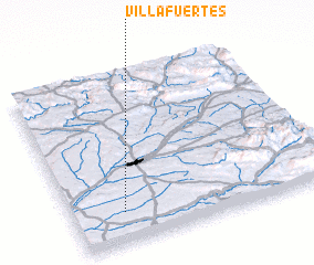 Places with similar names to Villafuertes, Spain ::
// Volovartsi (BG)
// Volfartice (CZ)
Disclaimer :: Information on this page comes without warranty of any kind |
||
|
Where is Villafuertes? Elevation and coordinates ::
Latitude (lat): 42°11'0"N Longitude (lon): 3°48'0"W
Elevation (approx.): 841m (map arrows pan, magnifying glasses zoom) |
||
|
Visiting Villafuertes? Hotel/Accommodation ::
Book a hotel in Villafuertes Travel Guide ::
Buy a travel guide for Spain rental cars ::
car rental offers GPS waypoint ::
download a GPX waypoint (PoI) of Villafuertes for your GPS receiver
|
||