|
search place name
|
||
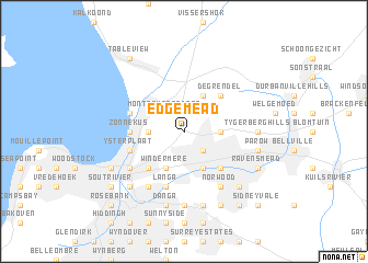
Edgemead (South Africa)Edgemead is a town in South Africa. An overview map of the region around Edgemead is displayed below.
regional and 3d topo map of Edgemead, South Africa ::
Edgemead airports ::
The nearest airport is CPT - Cape Town Intl, located 11.0 km south east of Edgemead.
Nearby towns ::
Montague Gardens (2.4km north west) //
Goodwood (2.4km south east) //
Sanddrift (3.1km west) //
Monte Vista (3.1km east) //
Bothasig (4.0km north east) //
Windermere (4.0km south west) //
Vasco (4.0km south east) //
Epping (4.0km south east) //
De Grendel (4.8km north east) //
Pinelands (4.8km south west) //
Kensington (4.8km south west) //
Elsiesrivier (4.8km south east) //
Zonnekus (4.6km west) //
Milnerton (5.0km west) //
Langa (5.8km south) //
Ysterplaat (5.0km west) //
Rugby (5.0km west) //
Maitland (6.4km south west) //
Brooklyn (5.9km south west) //
Epping Forest (6.4km south east) //
Norwood (6.4km south east) //
Tygerberg Hills (6.2km east) //
Bridgetown (7.4km south) //
Danga (7.6km south) //
Parow (6.4km east) //
Bontheuwel (7.6km south) //
Garden Village (7.2km south west) //
Eureka (7.2km south east) //
Matroosfontein (7.2km south east) //
[all distances 'as the bird flies' and approximate] 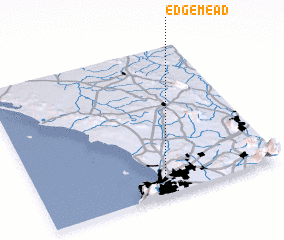 Places with similar names to Edgemead, South Africa ::
// Ej Jeimat (MA)
Disclaimer :: Information on this page comes without warranty of any kind |
||
|
Where is Edgemead? Elevation and coordinates ::
Latitude (lat): 33°53'0"S Longitude (lon): 18°32'0"E
Elevation (approx.): 23m (map arrows pan, magnifying glasses zoom) |
||
|
Visiting Edgemead? Hotel/Accommodation ::
Book a hotel in Edgemead Travel Guide ::
rental cars ::
car rental offers GPS waypoint ::
download a GPX waypoint (PoI) of Edgemead for your GPS receiver
|
||