|
search place name
|
||
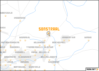
Sonstraal (South Africa)Sonstraal is a town in South Africa. An overview map of the region around Sonstraal is displayed below.
regional and 3d topo map of Sonstraal, South Africa ::
Sonstraal airports ::
The nearest airport is CPT - Cape Town Intl, located 15.3 km south of Sonstraal.
Nearby towns ::
Durbanville (0.0km north) //
Schoongezicht (1.9km north) //
Durbanville Hills (2.4km south west) //
Stellenberg (3.7km south) //
Eversdal (3.7km south) //
Kenridge (4.0km south west) //
Welgemoed (4.8km south west) //
Brackenfell (4.8km south east) //
Blomtuin (5.6km south) //
Windsor Park (5.0km east) //
Bellville (7.6km south) //
Kraaifontein (6.4km east) //
Tygerberg Hills (7.2km south west) //
Parow (8.7km south west) //
[all distances 'as the bird flies' and approximate] 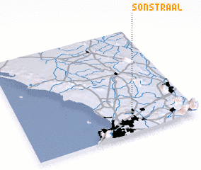 Places with similar names to Sonstraal, South Africa ::
// Sonstraal (ZA)
Disclaimer :: Information on this page comes without warranty of any kind |
||
|
Where is Sonstraal? Elevation and coordinates ::
Latitude (lat): 33°50'0"S Longitude (lon): 18°39'0"E
Elevation (approx.): 157m (map arrows pan, magnifying glasses zoom) |
||
|
Visiting Sonstraal? Hotel/Accommodation ::
Book a hotel in Sonstraal Travel Guide ::
rental cars ::
car rental offers GPS waypoint ::
download a GPX waypoint (PoI) of Sonstraal for your GPS receiver
|
||