|
search place name
|
||
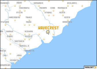
Wavecrest (South Africa)Wavecrest is a town in South Africa. An overview map of the region around Wavecrest is displayed below.
regional and 3d topo map of Wavecrest, South Africa ::
Wavecrest airports ::
The nearest airport is ELS - East London, located 80.6 km south west of Wavecrest.
Other airports nearby include UTT - Umtata Mthatha (116.0 km north), VIY - Bisho Bhisho (119.6 km west), UTW - Queenstown (169.3 km north west), MGH - Margate (259.1 km north east), Nearby towns ::
Kobonqaba (1.9km north) //
Nxaxo Mouth (1.6km east) //
Groxozayo (2.4km north west) //
Kobonqaba (2.4km south west) //
KwaDebese (3.1km west) //
Dyashi (6.0km north west) //
Mtwaku (7.4km north) //
Ncerana (6.2km west) //
Cebe (7.6km north) //
Ncizele (6.5km west) //
Manyana (6.5km west) //
Nousi (7.3km north west) //
Masazane (7.3km north east) //
Cebe (7.3km north east) //
Ncata (8.8km north east) //
Takazi (8.4km north west) //
Ngingqini (8.4km north west) //
Ncata (8.4km north east) //
Trennerys (9.7km south west) //
[all distances 'as the bird flies' and approximate]  Places with similar names to Wavecrest, South Africa ::
// Wavecrest (ZA)
// Wave Crest (US)
Disclaimer :: Information on this page comes without warranty of any kind |
||
|
Where is Wavecrest? Elevation and coordinates ::
Latitude (lat): 32°35'0"S Longitude (lon): 28°30'0"E
Elevation (approx.): 32m (map arrows pan, magnifying glasses zoom) |
||
|
Visiting Wavecrest? Hotel/Accommodation ::
Book a hotel in Wavecrest Travel Guide ::
rental cars ::
car rental offers GPS waypoint ::
download a GPX waypoint (PoI) of Wavecrest for your GPS receiver
|
||