|
search place name
|
||
Wyndover (South Africa)Wyndover is a town in South Africa. An overview map of the region around Wyndover is displayed below.
regional and 3d topo map of Wyndover, South Africa ::

Wyndover airports ::
The nearest airport is CPT - Cape Town Intl, located 11.1 km east of Wyndover.
Nearby towns ::
Nuweland (1.9km north) //
Claremont (1.5km west) //
Crawford (1.5km east) //
Lansdowne (1.5km east) //
Hiddingh (2.4km north west) //
Athlone (2.4km north east) //
Wynberg (2.4km south west) //
Bishopscourt (3.1km west) //
Wynberg Hill (3.1km west) //
Fernwood (3.1km west) //
Belthorn (3.1km east) //
Ottery (3.7km south) //
Rosebank (4.0km north west) //
Sunnyside (3.6km north east) //
Plumstead (4.0km south west) //
Welton (3.6km south east) //
Danga (4.8km north east) //
Doordrift (4.8km south west) //
Constantia (4.8km south west) //
Alphen (4.8km south west) //
Hanover Park (4.6km east) //
Garden Village (5.6km north) //
Glen Dirk (4.6km west) //
Southfield (5.6km south) //
Observatory (5.8km north) //
Mowbray (5.8km north) //
Soutrivier (5.8km north) //
Rylands Estate (5.0km east) //
Silvertown (5.0km east) //
[all distances 'as the bird flies' and approximate] 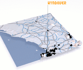 Places with similar names to Wyndover, South Africa ::
// Näduvere (EE)
// New Dover (US)
// New Dover (US)
// Ndiéfèr (SN)
// Ndevoira (FJ)
// Ndaforo (NG)
// Nadveri (PG)
// Nattavaara (SE)
// Nattavaara (SE)
Disclaimer :: Information on this page comes without warranty of any kind |
||
|
Where is Wyndover? Elevation and coordinates ::
Latitude (lat): 33°59'0"S Longitude (lon): 18°29'0"E
Elevation (approx.): 27m (map arrows pan, magnifying glasses zoom) |
||
|
Visiting Wyndover? Hotel/Accommodation ::
Book a hotel in Wyndover Travel Guide ::
rental cars ::
car rental offers GPS waypoint ::
download a GPX waypoint (PoI) of Wyndover for your GPS receiver
|
||