|
search place name
|
||
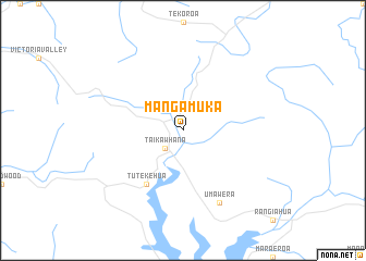
Mangamuka (Akaroa, New Zealand)Mangamuka is a town in the Akaroa region of New Zealand. An overview map of the region around Mangamuka is displayed below.
regional and 3d topo map of Mangamuka, New Zealand ::
Mangamuka airports ::
The nearest airport is KAT - Kaitaia, located 29.1 km north west of Mangamuka.
Other airports nearby include KKE - Kerikeri (33.3 km east), WRE - Whangarei (96.0 km south east), AKL - Auckland Intl (228.0 km south east), Nearby towns ::
Taikawhana (2.4km south west) //
Tutekehua (6.3km south west) //
Umawera (8.0km south) //
[all distances 'as the bird flies' and approximate] 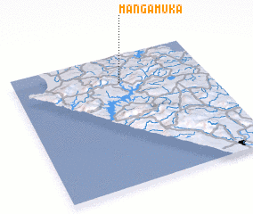 Places with similar names to Mangamuka, New Zealand ::
// Mān Kūmka (MM)
// Mān Kūmkai (MM)
// Mangomuca (MZ)
// Muang Mok (LA)
// Mang May (2) (VN)
// Mangômuca (GW)
Disclaimer :: Information on this page comes without warranty of any kind |
||
|
Where is Mangamuka? Elevation and coordinates ::
Latitude (lat): 35°13'0"S Longitude (lon): 173°33'0"E
Elevation (approx.): 60m (map arrows pan, magnifying glasses zoom) |
||
|
Visiting Mangamuka? Hotel/Accommodation ::
Book a hotel in Mangamuka Travel Guide ::
Buy a travel guide for New Zealand rental cars ::
car rental offers GPS waypoint ::
download a GPX waypoint (PoI) of Mangamuka for your GPS receiver
|
||