|
search place name
|
||
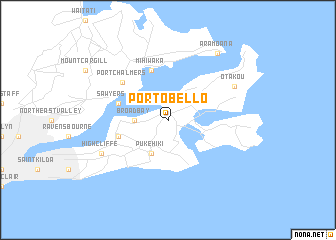
Portobello (Akaroa, New Zealand)Portobello is a town in the Akaroa region of New Zealand. An overview map of the region around Portobello is displayed below.
regional and 3d topo map of Portobello, New Zealand ::
Portobello airports ::
The nearest airport is DUD - Dunedin, located 36.1 km west of Portobello.
Other airports nearby include OAM - Oamaru (103.5 km north), ALR - Alexandra (122.4 km north west), WKA - Wanaka (166.9 km north west), ZQN - Queenstown International Queenstown (175.6 km north west), Nearby towns ::
Broad Bay (2.6km west) //
Pukehiki (3.9km south) //
Mihiwaka (5.7km north) //
Macandrew Bay (4.3km south west) //
Sawyers Bay (4.3km north west) //
Port Chalmers (5.5km north west) //
Otakou (6.4km north east) //
Highcliffe (6.4km south west) //
Aramoana (8.4km north east) //
[all distances 'as the bird flies' and approximate]  Places with similar names to Portobello, New Zealand ::
// Paratubal (BR)
// Portobelo (PA)
// Portobello (ZA)
// Portobello (US)
// Porta Bello (US)
// Porto Bello (CO)
// Portobelo (CO)
// Puerto Balao (EC)
// Port Bell (UG)
// Puerto Bello (VE)
Disclaimer :: Information on this page comes without warranty of any kind |
||
|
Where is Portobello? Elevation and coordinates ::
Latitude (lat): 45°51'0"S Longitude (lon): 170°39'0"E
Elevation (approx.): 80m (map arrows pan, magnifying glasses zoom) |
||
|
Visiting Portobello? Hotel/Accommodation ::
Book a hotel in Portobello Travel Guide ::
Buy a travel guide for New Zealand rental cars ::
car rental offers GPS waypoint ::
download a GPX waypoint (PoI) of Portobello for your GPS receiver
|
||