|
search place name
|
||
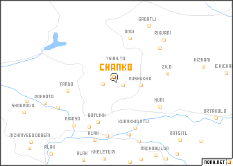
Chanko (Dagestan, Russia)Chanko is a town in the Dagestan region of Russia. An overview map of the region around Chanko is displayed below.
regional and 3d topo map of Chanko, Russia ::
Chanko airports ::
The nearest airport is MCX - Makhachkala Uytash, located 115.7 km east of Chanko.
Nearby towns ::
Shivor (0.9km south east) //
Ankho (1.1km north west) //
Tasuta (1.6km west) //
Tsibilta (2.8km north) //
Rushukha (3.0km east) //
Botlikh (6.6km south) //
Andi (7.4km north) //
Kvankhidatli (7.7km south) //
Muni (6.4km south east) //
Tando (5.9km west) //
Miarso (7.7km south west) //
Zilo (6.2km east) //
Nizhneye Inkhelo (8.4km south) //
Botlikh (8.6km south) //
Ashali (7.6km north east) //
Miarso (8.6km south west) //
Rikvani (9.0km north east) //
[all distances 'as the bird flies' and approximate] 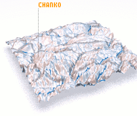 Places with similar names to Chanko, Russia ::
Disclaimer :: Information on this page comes without warranty of any kind |
||
|
Where is Chanko? Elevation and coordinates ::
Latitude (lat): 42°43'15"N Longitude (lon): 46°14'40"E
Elevation (approx.): 1573m (map arrows pan, magnifying glasses zoom) |
||
|
Visiting Chanko? Hotel/Accommodation ::
Book a hotel in Chanko Travel Guide ::
Buy a travel guide for Russia rental cars ::
car rental offers GPS waypoint ::
download a GPX waypoint (PoI) of Chanko for your GPS receiver
|
||