|
search place name
|
||
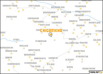
Chigarikha (Tverskaya Oblast', Russia)Chigarikha is a town in the Tverskaya Oblast' region of Russia. An overview map of the region around Chigarikha is displayed below.
regional and 3d topo map of Chigarikha, Russia ::
Chigarikha airports ::
The nearest airport is KLD - Tver Migalovo, located 81.1 km east of Chigarikha.
Nearby towns ::
Ramenki (1.3km south east) //
Fomishikha (2.5km north west) //
Skrylëvo (3.8km north) //
Kaftyrevo (2.6km north east) //
Ryabinikha (3.2km south west) //
Luzhkovo (4.4km north) //
Korshevo (5.3km north west) //
Babino (6.5km north) //
Rusino (4.5km east) //
Andreanovo (8.0km north) //
Yelizavetino (5.1km south east) //
Polishino (4.6km east) //
Konyshkovo (6.4km south east) //
Boristsevo (6.6km south west) //
Khrapyni (8.6km south) //
Ivankovo (5.3km north east) //
Kupishikha (6.9km north west) //
Prusovo (8.0km north) //
Zador'ye (6.5km north east) //
Babinskoye (9.0km south) //
Skrylëvo (8.6km north) //
Bosharovo (8.5km south west) //
Pustoradikha (9.3km south west) //
[all distances 'as the bird flies' and approximate]  Places with similar names to Chigarikha, Russia ::
// Chigarikha (RU)
// Shua-Krikhi (GE)
Disclaimer :: Information on this page comes without warranty of any kind |
||
|
Where is Chigarikha? Elevation and coordinates ::
Latitude (lat): 56°48'32"N Longitude (lon): 34°25'49"E
Elevation (approx.): 258m (map arrows pan, magnifying glasses zoom) |
||
|
Visiting Chigarikha? Hotel/Accommodation ::
Book a hotel in Chigarikha Travel Guide ::
Buy a travel guide for Russia rental cars ::
car rental offers GPS waypoint ::
download a GPX waypoint (PoI) of Chigarikha for your GPS receiver
|
||