|
search place name
|
||
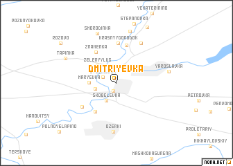
Dmitriyevka (Tambovskaya Oblast', Russia)Dmitriyevka is a town in the Tambovskaya Oblast' region of Russia. An overview map of the region around Dmitriyevka is displayed below.
regional and 3d topo map of Dmitriyevka, Russia ::
Dmitriyevka airports ::
The nearest airport is VOZ - Voronezh Chertovitskoye, located 159.8 km south west of Dmitriyevka.
Nearby towns ::
Nikiforovka (1.3km south) //
Lyubimovka (1.7km north west) //
Skobelevka (3.0km south) //
Malaya Orlova Luka (2.3km south west) //
Zelënyy Lug (3.4km north west) //
Mar'yevka (2.6km west) //
Vostochnaya Starinka (5.1km south west) //
Znamenka (5.3km north) //
Sychëvka (6.2km north) //
Krasnyy Gorodok (6.5km north) //
Zapadnaya Starinka (5.1km south west) //
Svetlaya Zhizn' (6.9km north) //
Ozerki (7.9km south) //
Malaya Sychëvka (8.4km north) //
Smorodinka (8.2km north) //
Yaroslavka (5.4km east) //
Tapinka (6.3km north west) //
[all distances 'as the bird flies' and approximate]  Places with similar names to Dmitriyevka, Russia ::
// Dmitriyevka (UA)
// Dmitriyevka (UA)
// Dmitriyevka (UA)
// Dmitriyevka (UA)
// Dmitriyevka (UA)
// Dmitriyevka (UA)
// Dmitriyevka (UA)
// Dmitriyevka (UA)
// Dmitriyevka (UA)
// Dimitriyevka (RU)
Disclaimer :: Information on this page comes without warranty of any kind |
||
|
Where is Dmitriyevka? Elevation and coordinates ::
Latitude (lat): 52°53'31"N Longitude (lon): 40°46'51"E
Elevation (approx.): 139m (map arrows pan, magnifying glasses zoom) |
||
|
Visiting Dmitriyevka? Hotel/Accommodation ::
Book a hotel in Dmitriyevka Travel Guide ::
Buy a travel guide for Russia rental cars ::
car rental offers GPS waypoint ::
download a GPX waypoint (PoI) of Dmitriyevka for your GPS receiver
|
||