|
search place name
|
||
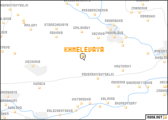
Khmelëvaya (Orlovskaya Oblast', Russia)Khmelëvaya is a town in the Orlovskaya Oblast' region of Russia. An overview map of the region around Khmelëvaya is displayed below.
regional and 3d topo map of Khmelëvaya, Russia ::
Khmelëvaya airports ::
The nearest airport is VOZ - Voronezh Chertovitskoye, located 118.2 km south east of Khmelëvaya.
Nearby towns ::
Tikhiy Ugolok (1.5km north) //
Rovenskiye Vyselki (4.5km south east) //
(( Kazinka )) (5.4km north) //
Gnilovody (6.3km north) //
Novinka (6.4km north west) //
Khukhlovo (6.6km north east) //
Kruten'kiy (5.7km south east) //
Berezhki (7.7km north east) //
Prechistenskoye (6.2km north east) //
Storozhevaya (8.0km north west) //
Bykovo (6.6km north east) //
Rovenka (7.5km south east) //
Romanovka (8.9km north east) //
[all distances 'as the bird flies' and approximate]  Places with similar names to Khmelëvaya, Russia ::
// Khmelëvaya (UA)
// Khmelevoye (UA)
// Khmelevoye (UA)
// Khmelëvaya (RU)
// Khmelëvaya (RU)
// Khmelëvaya (RU)
// Khmelëvaya (RU)
// Khmelëvaya (RU)
// Khmelevaya (RU)
// Khmelevaya (RU)
Disclaimer :: Information on this page comes without warranty of any kind |
||
|
Where is Khmelëvaya? Elevation and coordinates ::
Latitude (lat): 52°28'13"N Longitude (lon): 37°52'20"E
Elevation (approx.): 188m (map arrows pan, magnifying glasses zoom) |
||
|
Visiting Khmelëvaya? Hotel/Accommodation ::
Book a hotel in Khmelëvaya Travel Guide ::
Buy a travel guide for Russia rental cars ::
car rental offers GPS waypoint ::
download a GPX waypoint (PoI) of Khmelëvaya for your GPS receiver
|
||