|
search place name
|
||
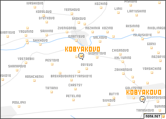
Kobyakovo (Moskovskaya Oblast', Russia)Kobyakovo is a town in the Moskovskaya Oblast' region of Russia. An overview map of the region around Kobyakovo is displayed below.
regional and 3d topo map of Kobyakovo, Russia ::
Kobyakovo airports ::
The nearest airport is VKO - Moscow Vnukovo, located 25.9 km east of Kobyakovo.
Other airports nearby include SVO - Moscow Sheremetyevo (46.9 km north east), KLD - Tver Migalovo (145.4 km north west), Nearby towns ::
Timokhovo (1.0km north west) //
Rayëvo (2.1km south) //
Vvedenskoye (2.1km north east) //
Bogachëvo (2.8km south) //
Skorotovo (1.9km east) //
Klopovo (2.7km north west) //
Ignat'yevo (4.4km north) //
Brëkhovo-Krest'yanskoye (4.9km south) //
Sal'kovo (4.6km north east) //
Pokrovskoye-Zasekino (4.3km south west) //
Mozhinka (6.3km north) //
Chastsy (6.7km south) //
Pestovo (4.1km west) //
Zvenigorod (6.5km north) //
Suponevo (8.0km north) //
Kozino (6.9km north east) //
Skokovo (8.3km north) //
Chigasovo (4.9km east) //
Dunino (6.5km north east) //
Savvino (7.2km north west) //
Tatarki (8.3km south west) //
Butyn' (9.5km south east) //
Dyut'kovo (9.6km north west) //
[all distances 'as the bird flies' and approximate]  Places with similar names to Kobyakovo, Russia ::
Disclaimer :: Information on this page comes without warranty of any kind |
||
|
Where is Kobyakovo? Elevation and coordinates ::
Latitude (lat): 55°40'41"N Longitude (lon): 36°52'49"E
Elevation (approx.): 187m (map arrows pan, magnifying glasses zoom) |
||
|
Visiting Kobyakovo? Hotel/Accommodation ::
Book a hotel in Kobyakovo Travel Guide ::
Buy a travel guide for Russia rental cars ::
car rental offers GPS waypoint ::
download a GPX waypoint (PoI) of Kobyakovo for your GPS receiver
|
||