|
search place name
|
||
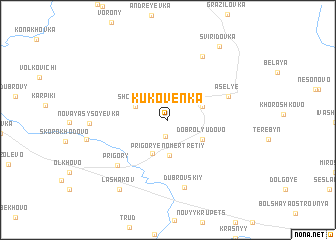
Kukoven'ka (Smolenskaya Oblast', Russia)Kukoven'ka is a town in the Smolenskaya Oblast' region of Russia. An overview map of the region around Kukoven'ka is displayed below.
regional and 3d topo map of Kukoven'ka, Russia ::
Kukoven'ka airports ::
The nearest airport is BZK - Bryansk, located 97.7 km south east of Kukoven'ka.
Nearby towns ::
Tsyganovka (1.9km south) //
Shchedra (2.6km north west) //
Prigor'ye Nomer Tretiy (4.0km south) //
Khortovka (2.7km north east) //
Prigor'ye (3.9km south) //
Dobrolyudovo (3.1km south east) //
Asel'ye (4.8km north east) //
Prigory (6.1km south west) //
Dubrovskiy (7.6km south) //
Kamenistyy (7.5km north) //
Novaya Sysoyevka (5.1km west) //
Lashakov (8.4km south west) //
Sviridovka (8.8km north east) //
[all distances 'as the bird flies' and approximate]  Places with similar names to Kukoven'ka, Russia ::
// Côc Phong (VN)
// Côc Phương (VN)
// Cốc Phường (VN)
// Coc Phuong (VN)
// Cúc Phương (VN)
// Cúc Phưởng (VN)
// Koc Phong (VN)
Disclaimer :: Information on this page comes without warranty of any kind |
||
|
Where is Kukoven'ka? Elevation and coordinates ::
Latitude (lat): 53°51'10"N Longitude (lon): 33°9'56"E
Elevation (approx.): 203m (map arrows pan, magnifying glasses zoom) |
||
|
Visiting Kukoven'ka? Hotel/Accommodation ::
Book a hotel in Kukoven'ka Travel Guide ::
Buy a travel guide for Russia rental cars ::
car rental offers GPS waypoint ::
download a GPX waypoint (PoI) of Kukoven'ka for your GPS receiver
|
||