|
search place name
|
||
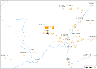
Landa (Dagestan, Russia)Landa is a town in the Dagestan region of Russia. An overview map of the region around Landa is displayed below.
regional and 3d topo map of Landa, Russia ::
Landa airports ::
The nearest airport is MCX - Makhachkala Uytash, located 131.2 km north east of Landa.
Nearby towns ::
Khintida (0.5km north west) //
Bochokh (0.7km north east) //
Zhantakolob (1.2km east) //
Tokh (1.4km north east) //
Kharada (1.5km north west) //
Nukhotkolob (1.8km north west) //
Khadakolob (2.0km north west) //
Tagada (2.3km north) //
Shidib (2.1km east) //
Santa (3.3km north west) //
Sanatoriy (3.6km south east) //
Chododa (4.0km south east) //
Kalda (4.1km east) //
Chadakolob (4.6km south east) //
Katroso (5.1km south east) //
Machar (5.0km east) //
Kabasida (5.4km east) //
Antsukh (6.0km south east) //
(( Kul'zeb )) (6.3km east) //
Alikuli (7.1km south east) //
Garbutl' (8.2km south west) //
Gebguda (7.2km south east) //
Childa (8.3km south east) //
[all distances 'as the bird flies' and approximate]  Places with similar names to Landa, Russia ::
Disclaimer :: Information on this page comes without warranty of any kind |
||
|
Where is Landa? Elevation and coordinates ::
Latitude (lat): 42°13'1"N Longitude (lon): 46°16'36"E
Elevation (approx.): 1508m (map arrows pan, magnifying glasses zoom) |
||
|
Visiting Landa? Hotel/Accommodation ::
Book a hotel in Landa Travel Guide ::
Buy a travel guide for Russia rental cars ::
car rental offers GPS waypoint ::
download a GPX waypoint (PoI) of Landa for your GPS receiver
|
||