|
search place name
|
||
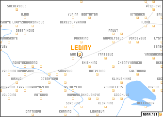
Lediny (Tverskaya Oblast', Russia)Lediny is a town in the Tverskaya Oblast' region of Russia. An overview map of the region around Lediny is displayed below.
regional and 3d topo map of Lediny, Russia ::
Lediny airports ::
The nearest airport is KLD - Tver Migalovo, located 151.5 km south of Lediny.
Nearby towns ::
Dor (1.0km west) //
Shishkino (2.1km south east) //
Vakarino (3.7km north) //
Matrënino (4.2km south east) //
Sidorovo (4.2km south west) //
Yartsevo (2.9km east) //
Kotlovan (4.7km south west) //
Kuznetskoye (5.9km south) //
Berëzovaya Niva (7.5km north) //
Sukovatikha (4.3km south east) //
Astaf'yevo (7.5km south) //
Pashnevo (5.4km north east) //
Gavril'tsevo (5.4km north east) //
Staryy Ryad (5.4km south west) //
Boronatovo (7.7km south) //
Prudy (6.8km north east) //
Artem'yevo (6.8km south west) //
Fominskoye (6.8km south west) //
Pogorelets (8.4km south east) //
Krasnoye (8.4km south east) //
[all distances 'as the bird flies' and approximate]  Places with similar names to Lediny, Russia ::
Disclaimer :: Information on this page comes without warranty of any kind |
||
|
Where is Lediny? Elevation and coordinates ::
Latitude (lat): 58°7'0"N Longitude (lon): 34°58'0"E
Elevation (approx.): 203m (map arrows pan, magnifying glasses zoom) |
||
|
Visiting Lediny? Hotel/Accommodation ::
Book a hotel in Lediny Travel Guide ::
Buy a travel guide for Russia rental cars ::
car rental offers GPS waypoint ::
download a GPX waypoint (PoI) of Lediny for your GPS receiver
|
||