|
search place name
|
||
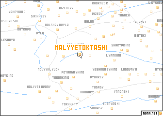
Malyye Toktashi (Chuvashiya, Russia)Malyye Toktashi is a town in the Chuvashiya region of Russia. An overview map of the region around Malyye Toktashi is displayed below.
regional and 3d topo map of Malyye Toktashi, Russia ::
Nearby towns ::
Bol'shiye Toktashi (1.2km north east) //
Raskil'dino (2.1km north) //
Okhverkino (2.1km north west) //
Shundryashi (2.4km west) //
Poyandaykino (4.6km south) //
Tautovo (4.8km north east) //
Kaderkino (3.6km south east) //
Pyukrey (5.9km south) //
Yeshmeneykino (4.9km south east) //
Shereshevo (6.9km north) //
Khodyakovo (5.8km north east) //
Yegorkino (6.3km south west) //
Savaderkino (7.3km south) //
Shlan (7.4km north) //
Il'yankino (4.3km east) //
Turi-Vyla (4.5km west) //
Novyy Klyuch (5.6km south west) //
Bol'shaya Vyla (7.2km north west) //
Pavlushkino (6.6km north east) //
Tugasy (8.2km south) //
Khora-Vary (7.0km north east) //
Tuvany (8.4km south west) //
Khirlepposi (8.5km north east) //
[all distances 'as the bird flies' and approximate]  Places with similar names to Malyye Toktashi, Russia :: Disclaimer :: Information on this page comes without warranty of any kind |
||
|
Where is Malyye Toktashi? Elevation and coordinates ::
Latitude (lat): 55°40'0"N Longitude (lon): 46°36'0"E
Elevation (approx.): 163m (map arrows pan, magnifying glasses zoom) |
||
|
Visiting Malyye Toktashi? Hotel/Accommodation ::
Book a hotel in Malyye Toktashi Travel Guide ::
Buy a travel guide for Russia rental cars ::
car rental offers GPS waypoint ::
download a GPX waypoint (PoI) of Malyye Toktashi for your GPS receiver
|
||