|
search place name
|
||
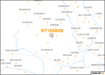
Mityushino (Smolenskaya Oblast', Russia)Mityushino is a town in the Smolenskaya Oblast' region of Russia. An overview map of the region around Mityushino is displayed below.
regional and 3d topo map of Mityushino, Russia ::
Nearby towns ::
Yemel'yanovo (1.1km north east) //
Turkovo (2.1km south west) //
Gorodok (3.4km north) //
Verzha (3.3km west) //
Ostashëvo (5.7km south) //
Isakovo (5.7km north) //
Klinkovo (5.6km north) //
Knyazevo (6.4km south west) //
Ivashkovo (7.8km north) //
Kozulino (5.4km north east) //
Nikolo-Pogoreloye (8.8km south) //
Spichino (8.1km south east) //
Rodionovo (8.5km north) //
Ploskaya (6.6km north west) //
Feshino (8.0km south east) //
[all distances 'as the bird flies' and approximate]  Places with similar names to Mityushino, Russia ::
// Matyushina (RU)
// Matyushina (RU)
// Matyushino (RU)
// Matyushino (RU)
// Matyushino (RU)
// Matyushino (RU)
// Mityushino (RU)
// Mityushino (RU)
// Mityushino (RU)
// Matyushino (RU)
Disclaimer :: Information on this page comes without warranty of any kind |
||
|
Where is Mityushino? Elevation and coordinates ::
Latitude (lat): 55°19'0"N Longitude (lon): 33°28'0"E
Elevation (approx.): 225m (map arrows pan, magnifying glasses zoom) |
||
|
Visiting Mityushino? Hotel/Accommodation ::
Book a hotel in Mityushino Travel Guide ::
Buy a travel guide for Russia rental cars ::
car rental offers GPS waypoint ::
download a GPX waypoint (PoI) of Mityushino for your GPS receiver
|
||