|
search place name
|
||
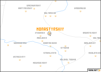
Monastyrskiy (Samarskaya Oblast', Russia)Monastyrskiy is a town in the Samarskaya Oblast' region of Russia. An overview map of the region around Monastyrskiy is displayed below.
regional and 3d topo map of Monastyrskiy, Russia ::
Monastyrskiy airports ::
The nearest airport is KBY - Samara Kurumoch, located 95.5 km north of Monastyrskiy.
Other airports nearby include URA - Uralsk (210.5 km south east), Nearby towns ::
Pavlovka (2.6km south west) //
V'yushkov (2.2km west) //
Khomyakovka (3.7km south) //
Yekaterinovka (5.0km south east) //
Stremleniye (7.4km south) //
Solyanikha (7.4km north) //
Kanevskiy (7.5km north) //
Mar'yevskiy (7.5km north) //
Sytovka (6.5km south east) //
[all distances 'as the bird flies' and approximate] 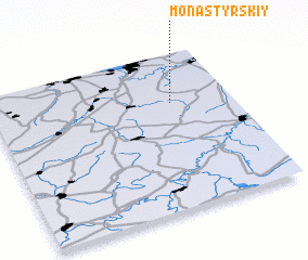 Places with similar names to Monastyrskiy, Russia ::
// Monasterzec (PL)
// Manastersko (UA)
// Monasteriska (UA)
// Manastirsko (BG)
// Monastyrskiy (RU)
// Monastyrys'ka (UA)
// Månsträsk (SE)
// Mensträsk (SE)
// Mensträsk (SE)
Disclaimer :: Information on this page comes without warranty of any kind |
||
|
Where is Monastyrskiy? Elevation and coordinates ::
Latitude (lat): 52°41'0"N Longitude (lon): 49°45'0"E
Elevation (approx.): 123m (map arrows pan, magnifying glasses zoom) |
||
|
Visiting Monastyrskiy? Hotel/Accommodation ::
Book a hotel in Monastyrskiy Travel Guide ::
Buy a travel guide for Russia rental cars ::
car rental offers GPS waypoint ::
download a GPX waypoint (PoI) of Monastyrskiy for your GPS receiver
|
||